Trails in Northern California

Trails in Northern California

Leave No Trace!

Visit desovw.org for more information about Desolation Wilderness. Visit Recreation.gov or call 1- 877-444-6777 to make park reservations. Visit Campfire Permits to get a permit online. More about Leave No Trace principles.
Showing posts with label waterfalls. Show all posts

June 02, 2016

Rock Creek Falls and One Eye Creek Trail 2016

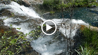
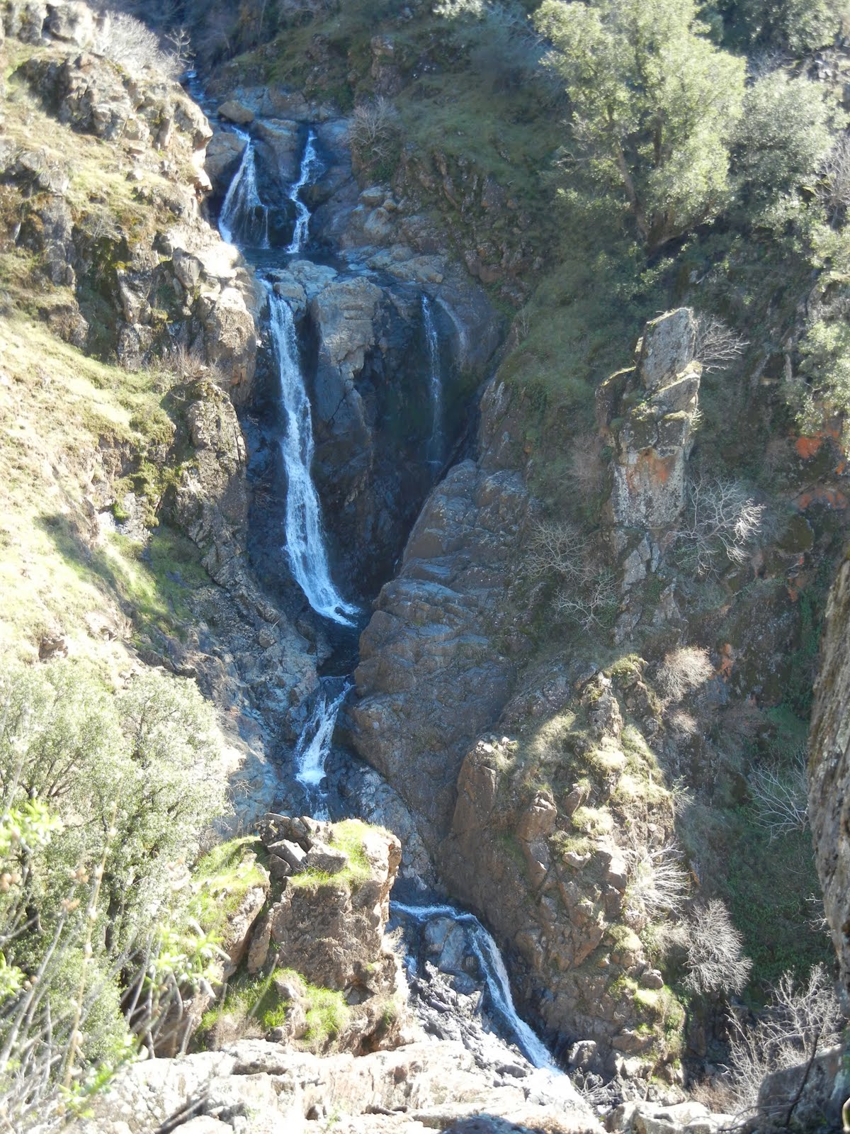
Rock Creek Falls is reported to be 100 feet across at times
Rock Creek Falls in May 2016

MILES: 6-7 miles
DIFFICULTY:  Moderate
ADVISORIES:  Poison Oak is everywhere!  The trail is steep, sometimes wet and slippery.

This marks the place you will either park or turn right and park at a junction of three roads.
 DIRECTIONS: 


1.      Take Highway 193 from Highway 49 toward Georgetown, California.

2.      If you are coming from Highway 50, turn right on Traverse Creek Road, or from Highway 80, turn left on Traverse Creek Road.

3.      Take Bear Creek Road to the right and pass Bear Creek Picnic area on the right (although this is a good place to stop and use restrooms since there aren't any at the trailhead).

4.      Continue for 0.7 miles to Forest Service Road 12N81 on the right, visible due to park signs posted.

5.      In winter park in the wide area on your left, and walk straight down the Forest Service Road until you come to the junction of three roads. In months the road is open you can drive back and park along here.

6.      Walk straight ahead and you will see a small post on your slight right at the One Eye Creek trailhead. Follow this trail all the way to the falls.

 At the beginning of the trail, there was scrub brush on either side, but the trail itself was clear and wouldn't be confused with animal trails. At one point it opened out into a small sunny meadow, but most of the area had manzanita and other brush.

Early on One Eye Creek Trail, these stickery bushes and vines had grown over the trail and caught on our backs and backpacks which made them a nuisance. The terrain is hilly and not too steep for any length of time until you descend to the creek and waterfalls. There was less poison oak in that area, except where the sun had more access to the trail. In May wildflowers were blooming.

A nice shady section is a tunnel.
And next is the most wild of all, the seeming meadow that when you look closely, you discover it is mostly poison oak!

About a mile into the trail you come to the "mine" shown below which is actually only a few feet deep, but a trail hazard that is fenced in with a small trail down the hill for hikers to see in.

The rolling trail finally opened up into this beautiful, cooler forest area that goes until you traverse downward to the creek.  Keep in mind it is deceiving because you are heading downward and on your return you will be heading upward, though slightly, you feel it.
.
After hiking all the way in, we had to bushwhack a little, but this time wasn't too bad.

 Going in we hiked the steady downhill and fairly easy trail. From about a mile away from the creek, we began to hear the waterfalls! As we made our way closer, the trail got steeper, and the pine needles were thickly layered and are sometimes slippery. Hiking poles and good shoes helped me navigate this section more safely.


 This section of trail could be dangerous due to steep slippery hills.  It makes having inexperienced hikers, inadequate equipment, or having children present inadvisable.  Lat/Long:38.82396, -120.759

It has been reported that the falls have been as much as 100 feet wide in flood stage. Here, there was a powerful current and as you can see, a large stretch of the 100 feet was, in fact, covered. The falls have also been estimated to be only a 25 foot drop, but with the current rushing almost violently, they were quite impressive!  To get to the bottom you had to creek cross and then climb down.  Others were there so we stayed up top beside the creek.

Our picnic spot along Bear Creek.
On our way out, we had to travel upward, and it felt steep and challenging in the wet, and especially with the weight of a backpack. Hiking poles really helped me there, too!


 Another alert: If you sat anywhere along the trail, it was on the damp ground with pine needles or poison oak! We also noted ticks, so check yourselves when you get out and wash all of your gear.

For fun here are some photos of wildflowers that were blooming:


This was a very worthwhile hike! On this trail, I have never met other hikers until this trip, when only two guys passed us, suggesting it gets little traffic, but the trail was in overall adequate condition. The views were memorable, and the trail was well marked. It isn't for the casual city hiker, due to the length and the difficulty near the falls. The elevation changes also required fitness, and being accustomed to ups and downs. Take some food, wear good hiking shoes with deep tread, and maybe take something dry to sit on in case it’s wet. Again, my hiking poles were helpful, especially on the climb out of the creek canyon. I wouldn't advise taking kids due to length, safety and difficulty level, until you have done the hike yourself and can make your own judgment about their abilities. Don't forget the camera!

The closest hikes you may also be interested in:
2010-06
3 miles
Difficult
2014-06
Stifle Claim Trail (Traverse Botanical Special Interest Area)
0+ miles
Easy +
2010-04
7 miles with closed road, 6 when it is opened
Moderate

or see the Table of Contents.

June 25, 2013

Lawrence Lake in Desolation Wilderness

Lawrence Lake is secluded, offers level campsites,

and is a perfect basecamp to explore surrounding

lakes and waterfalls.

Lawrence Lake, June 2013
Directions:  
Take Highway 50 E and turn north on Ice House Road.  Follow the signs to Wrights Lake and park at the Rockbound Trailhead. 
OR  (a better drive if you ask me):

Take the Wrights Lake Road north (between the 36 mile tract and the 39 mile tract) in the vicinity of Kyburz off Highway 50 and follow the signs.

Difficulty and Distance: I rate this as strenuous due to the length (no less than 13 miles round trip) and the rocky road and creek crossings.  Overall though, it is a fun, pleasant hike and is Easy to Moderate as a backpack trip.
Park at the Rockbound Trailhead parking.  There is a restroom near the trailhead signs.
Jeep trail
Begin your hike on the jeep road rather than the actual Rockbound Trail.  It has a green gate across it, and is labeled. The road/trail was not being used by jeeps at this time this was written and the condition varies from good dirt road as shown, to 4-wheeling eroded and rocky road.

Our first creek crossing.  
That is our cohort, Marcia.
At this time the creeks are all low but you can imagine that hiking here earlier in the season or in a heavier snowfall year,  might be more challenging.
Columbine blooming among corn lilies.
A variety of wildflowers are in bloom all along the way.

Wide open views
After winding through the woods, the trail opens out to large granite areas with gorgeous views.
Mariposa Lilies


Large meadow / "skeeters kitchen."
The trail takes you through a couple of these large mountain meadows that are alive with biting, buzzing, carnivorous, bugs and mosquitoes.

More creeks to cross.  (That is actually Chris!)


The creeks have rocks you can mostly use for dry crossings but hiking poles
sure help balance on themAll the rocks are not stable so check before you step!
Out of place restroom!
Near Barrett Lake this surprising bathroom sits to the side of the trail!

Barrett Lake
At Barrett there are open, large campsites with fire pits,
(no fires are allowed
 at this time).  The campsites offer little privacy.

Lawrence Lake
Keep hiking along the now single file trail that heads north to Lawrence Lake.

Super Moon June 2013

This was the super moon rising over the lake at 10:30 pm. 

Sunrise on Lawrence Lake
We camped along the north side of the lake but we discovered several good places to camp. 

The elevation graph shows you the highs and lows.  It really isn't a hard hike.  There are plenty of places to rest and if you have more energy it can be used exploring.  Along with the other lakes, there are waterfalls worth exploring.

This shows the route we hiked on this trip.  GPS is loaded here: Lawrence Lake .
Hike data.

Lawrence Lake makes a great basecamp to explore the surrounding lakes shown above.

For more hikes check Peachy's Trails by Location
with mileage and difficulty ratings, and
these Desolation Wilderness Trails:
Related Posts you might be interested in for nearby trails:

Desolation Wilderness
2015-07
10+ miles
Strenuous
2014-08
30 miles
Moderate to Strenuous/Difficult
2014-07
18 miles
Moderate-Difficult
2014-06
12+ miles
Moderate to Strenuous
2013-06
13+ miles
Moderate to Strenuous
2012-09
Umpa Lake & Enchanted Pools
8+ miles
Cross country ~ Moderate
2012-08
Horsetail Falls via Pyramid Creek TH
Aprox.  10 miles to lakes at the top of the falls
"Difficult, and potentially dangerous" miles
2012-07
10 miles
Moderate
2012-07
8 miles
Moderate-Strenuous
2012-06
Lyons Lake via Lyons Creek Trail
10+ miles
Strenuous
2012-08
9.2 miles
Moderate
2012-06
6+ miles
Strenuous
2011-07
Lyons Creek Trail with melting snow
9+ miles
Moderate
2011-02
3.8 miles
Moderate
2010-09 We hiked 12 days.
167 total
Moderate to Strenuous

See the Full Table of Contents.
Added updated links and Table of Contents 06-2016
 Link for permits and other related information
Marcia introduced us to these individual packs of olives.  I am addicted!  Give them a try for the best backpacking snack food! 
HAPPY TRAILS!

And thanks to Chris F. for planning this trip!  She is searching
out the Hidden and Lost Lakes this year!  I was fortunate to join this unbelievable group of women backpacking! 
P.S. One more thing is that three of us carried bear canisters for our food and all complained about how heavy they are.  Lawrence Lake has plenty of trees to bear bag your food and personal items.  For more information about a good bear bagging system, check out Stick's Blog .

June 03, 2013

Coloma's Dutch Creek Falls and Johntown Falls


For Johntown and Dutch Creek Waterfalls GPS, maps, and more thorough information, click here.


Upper Dutch Falls on Sept 30, 2012.


The affectionately named "Ancient Lady" southwest of the Upper Dutch Falls 9-2012.


The top of Johntown Falls 9-2012

Take water with you as there is none very appealing to try to purify!
 

Dutch Creek Trail needs serious maintainance work to become safe, and beware of the poison oak you can barely see now.  It is everywhere, but leafless or with little white balls, but bare branches.  It is no less toxic to the allergic. 

In spring, here is what you may have to look forward to if we can get some volunteers to work on the trail:
The photo below is Johntown Falls at Coloma, CA. photographed by this blogger who lead this hiking day with a Meetup.com. hiking club.  The falls were glorious and the hikers equally enjoyable! Weather was warm and mild, the water flow was gorgeous, and the company exquisite!


The next one is a shot of the trail as it enters the woods. Looks pretty docile, huh?


A walk in the park, so to speak.


This is one of our feisty hikers...none too intimidated as the trail
becomes more rugged and less park-like.


These are more of our fantastic group with high spirits for the day, waiting to see what is in store.


     Some took this side trail down to see the Lower Dutch Creek Falls that sometimes forms two separate falls, side by side, that are dropping around, guessing here, 10 feet. At about this time, one of our hikers got hurt, and that makes this a good time to advise good hiking shoes, and for hikers to beware of the short steeper sections of this trail. It is not maintained in any way, and you'll find yourself having to go over or around obstacles like rock outcroppings or tree falls. I might as well mention there is poison oak around here too. At some times of the year it is leafless, so be careful what you grab. Stay on trail and I don't recommend shorts or short sleeves if you are allergic.


When we reached Dutch Creek Falls and Johntown Creek Falls some members took a nice break, while the group I affectionately call the "Bushwhacking Maniacs" climbed higher and closer to the falls and then on up to overlook both falls from as high as we could get.


The trail to the falls is narrow, occasionally steep, but good solid tread, and do-able.  For people thrown off by viewing a steep hillside from a narrow path, this might just be too scary.


These are Bushwhackers getting closer to the falls.


Following a few minutes photographing and enjoying the falls' spray, we headed UP through loose rock, through dry weeds and stickers, over boulders, to the top!

Look, no hands!  Another hint.  Watch and listen for rattlesnakes.


This is the top of Johntown Creek Falls; the first photograph on this entry is the same falls.


From the top, we had excellent views of the entire Dutch Creek Falls.
It was worth every sticker I brought home!


Here is the view downstream of both falls. Can you find all the poison oak
Again, take precautions because it IS there!


Here are your blog writer and photographer with a fellow bushwhacker who wore, note, motorcycle pants on this adventure!
Some photos included courtesy of our hiking club members.
This was a most excellent day!

Directions:

  • Go to Coloma on CA 49 between I-80 and Highway 50; pay for parking at the parking lot kiosk.  
  • Walk over the one lane bridge. (You can't miss it as the town is VERY small.) 
  • Turn right on Bayne and follow the paved road to the locked green gate on the left across from the house downhill by the river. It is also identifiable by small signs like rattlesnake warnings, says "State Park", and is a regular locked forestry green gate you climb over or through.
  • The trail is single file, but visible. 
It leads through the grassy meadow, into the trees, and then has some steep ups and downs, but they are short. There is some brush, a couple of tree falls you have to climb over, under, or around.  The trail is hard wet soil mostly.  Hiking pole(s) are handy balancing tools. If I can give any advice, it is wear GOOD hiking shoes. Follow the trail to the falls! Have an adventurous and happy day!
Latitude: 38-47'57'' N

Longitude: 120-52'54'' W
Thank you for checking in! There is another review of this hike on this blog dated April of 2010, and has some other information, and beautiful photos showing the differences you can come across.

Peachy Hiker's Table of Contents   Dutch Creek Trail in June 2013
updated 6-2013 with photos and cautions!