Trails in Northern California

Trails in Northern California

Leave No Trace!

Visit desovw.org for more information about Desolation Wilderness. Visit Recreation.gov or call 1- 877-444-6777 to make park reservations. Visit Campfire Permits to get a permit online. More about Leave No Trace principles.
Showing posts with label Northern CA hikes. Show all posts

June 03, 2013

Coloma's Dutch Creek Falls and Johntown Falls


For Johntown and Dutch Creek Waterfalls GPS, maps, and more thorough information, click here.


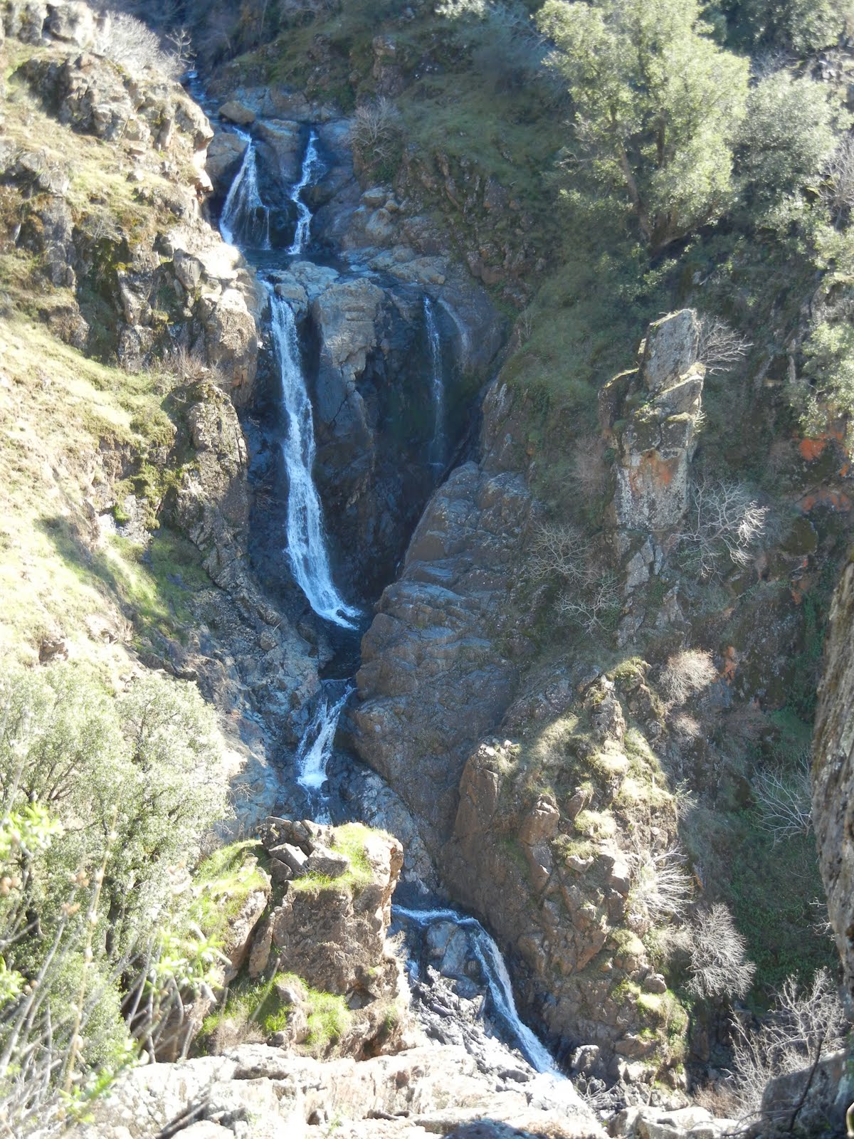
Upper Dutch Falls on Sept 30, 2012.


The affectionately named "Ancient Lady" southwest of the Upper Dutch Falls 9-2012.


The top of Johntown Falls 9-2012

Take water with you as there is none very appealing to try to purify!
 

Dutch Creek Trail needs serious maintainance work to become safe, and beware of the poison oak you can barely see now.  It is everywhere, but leafless or with little white balls, but bare branches.  It is no less toxic to the allergic. 

In spring, here is what you may have to look forward to if we can get some volunteers to work on the trail:
The photo below is Johntown Falls at Coloma, CA. photographed by this blogger who lead this hiking day with a Meetup.com. hiking club.  The falls were glorious and the hikers equally enjoyable! Weather was warm and mild, the water flow was gorgeous, and the company exquisite!


The next one is a shot of the trail as it enters the woods. Looks pretty docile, huh?


A walk in the park, so to speak.


This is one of our feisty hikers...none too intimidated as the trail
becomes more rugged and less park-like.


These are more of our fantastic group with high spirits for the day, waiting to see what is in store.


     Some took this side trail down to see the Lower Dutch Creek Falls that sometimes forms two separate falls, side by side, that are dropping around, guessing here, 10 feet. At about this time, one of our hikers got hurt, and that makes this a good time to advise good hiking shoes, and for hikers to beware of the short steeper sections of this trail. It is not maintained in any way, and you'll find yourself having to go over or around obstacles like rock outcroppings or tree falls. I might as well mention there is poison oak around here too. At some times of the year it is leafless, so be careful what you grab. Stay on trail and I don't recommend shorts or short sleeves if you are allergic.


When we reached Dutch Creek Falls and Johntown Creek Falls some members took a nice break, while the group I affectionately call the "Bushwhacking Maniacs" climbed higher and closer to the falls and then on up to overlook both falls from as high as we could get.


The trail to the falls is narrow, occasionally steep, but good solid tread, and do-able.  For people thrown off by viewing a steep hillside from a narrow path, this might just be too scary.


These are Bushwhackers getting closer to the falls.


Following a few minutes photographing and enjoying the falls' spray, we headed UP through loose rock, through dry weeds and stickers, over boulders, to the top!

Look, no hands!  Another hint.  Watch and listen for rattlesnakes.


This is the top of Johntown Creek Falls; the first photograph on this entry is the same falls.


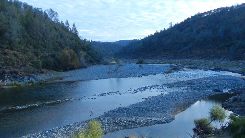
From the top, we had excellent views of the entire Dutch Creek Falls.
It was worth every sticker I brought home!


Here is the view downstream of both falls. Can you find all the poison oak
Again, take precautions because it IS there!


Here are your blog writer and photographer with a fellow bushwhacker who wore, note, motorcycle pants on this adventure!
Some photos included courtesy of our hiking club members.
This was a most excellent day!

Directions:

  • Go to Coloma on CA 49 between I-80 and Highway 50; pay for parking at the parking lot kiosk.  
  • Walk over the one lane bridge. (You can't miss it as the town is VERY small.) 
  • Turn right on Bayne and follow the paved road to the locked green gate on the left across from the house downhill by the river. It is also identifiable by small signs like rattlesnake warnings, says "State Park", and is a regular locked forestry green gate you climb over or through.
  • The trail is single file, but visible. 
It leads through the grassy meadow, into the trees, and then has some steep ups and downs, but they are short. There is some brush, a couple of tree falls you have to climb over, under, or around.  The trail is hard wet soil mostly.  Hiking pole(s) are handy balancing tools. If I can give any advice, it is wear GOOD hiking shoes. Follow the trail to the falls! Have an adventurous and happy day!
Latitude: 38-47'57'' N

Longitude: 120-52'54'' W
Thank you for checking in! There is another review of this hike on this blog dated April of 2010, and has some other information, and beautiful photos showing the differences you can come across.

Peachy Hiker's Table of Contents   Dutch Creek Trail in June 2013
updated 6-2013 with photos and cautions!

August 11, 2012

Cardiac Bypass North Fork Trail

In Folsom Lake State Recreation Area ~

Distance: On this weeks Cardiac Bypass Loop I hiked 5.75 miles round trip.  Go much more or some less depending on your choices.
Difficulty:  Moderate to Strenuous also based on your choices of using the road or trails more and the speed of your gait.
Elevation Changes:  Over 2400 feet total
Driving Directions:
  • From Highway 80 East from Sacramento area, take Indian Hill Road east from the Newcastle area.
  • Turn left on Auburn Folsom Road.
  • Turn right on Maidu Drive.  Park.  If you pay, it is $10. I parked along the road for free beyond the paid parking on Maidu Drive in Auburn, CA. Photos of options are below.
Advisories:  There are restrooms at the trailhead.  Poison oak is abundant along the sides of the trails.  Some areas have rocky footing.  There are small creek crossings.
* If you click on a photo all photos can then be viewed enlarged.
UPDATED photos taken March 8, 2016
Blue Dicks along hillsides, with swallowtails fluttering about, but quite a few other wildflowers too.

The North Fork of the American River is flowing freely thanks to all this recent rain.

Poison oak is everywhere so beware.


I had not used this section before and it took us all the way back to the starting point near the paid parking.  Shady, pleasant, and good footing.


This is the paid parking.  On the right you pull in and self register.  

The side of the road where you can park for free, or go beyond the gate shown above and park alongside the road there to hike the Bypass Trail.


The original article below is based on a variation of the hike shown above.  There are a multitude of trail choices as you go.  I advise getting GPS tracks or a map of the park trails if you are not familiar with the area and not secure finding your way in new places.
____________________________________________________

COUGAR SIGHTINGS ALERT!Yesterday, March 28th, 2013 a cougar was sighted near the "Y" along the trail.  There is some dense cover for it, so just be aware, be noisy, keep your eyes and ears open!  Bears have been sighted in the area in the past, so again, just be alert.


Distance: 7.2 miles using my GPS tracks, but more or less as you choose options.
Difficulty:  Moderate to Strenuous also based on your choices of using the road or trails more and the speed of your gait.
Elevation Changes:  Over 2400 feet total
Driving Directions: 
  • From Highway 80 East from Sacramento area, take Indian Hill Road east from the Newcastle area.
  • Turn left on Auburn Folsom Road.
  • Turn right on Maidu Drive.
  • You will see China Hill paid parking on the right with a restroom, or you can park along the roadway on the right also.  Walk through the closed park gate to begin the hike using the road as shown on the map below.
Notes:  There is paid parking available, or more recently I have been using Cardiac Hill Trail that is now well marked with park signs.  I park alongside Maidu Road at the gate marked for Cardiac Hill, just before a sign posting the entry to China Bar. There are restrooms at the trailhead posted on the GPS tracks, the icon for a bathroom in a large unused dirt parking area, and another at the car icon called "road end" which refers to an unused dirt road, small parking area. The trail that will take you winding mostly through trees along the river continues from there heading south.  Cardiac Hill is a vigorous hike or jog.  Its almost as steep as Training Hill, but prettier and shadier!


 Some volunteers have placed these small signs along the way to point you in the right direction.  (2016 update:  I did not see these signs anymore, but pretty well marked park signage)

 Going down to the river to rest and eat, maybe get wet, make the hike especially enjoyable for me.


 Some areas of the trails do get quite dry and full of stickers when the hills dry.  Gaiters over your boots or shoes help.  My hiking poles propel me uphill on the steep sections which unfortunately are the return trip!


Below is a graph to show you and give you a better idea of what to expect in elevation changes.

Related Area Hike Links:
ASRA ~ Auburn State Recreation District
BLM ~ Bureau of Land Management
Near Auburn, CA

Peachy Hiker's Table of Contents                                         

Updated March 10, 2016
Updated March 29th, 2013

July 09, 2012

Old Rubicon Trail Part A near Georgetown area

*  You can click on a photo and scroll through all of the photos enlarged for viewing in better detail.


The most memorable thing about this hike for me, aside from the heat, was the swarm of ladybugs near the turn around point of our hike.  We stood near a cliff to take photos of a chute where the river fought its way through.  The swarm was so thick we could see wee ladybugs over the river in our photos!  I was being bitten all over and had to leave the area.  When we got home I did some research and found out that this variety was imported for farming as a natural pesticide.  It is characteristic of them to try to get the salt off of you, and some sources claim that they don't bite...I beg to differ!  And it hurt!  And left those annoying red bumps just like mosquitoes.  Is there ladybug repellant???

Miles:  We hiked 1.9 miles each way but you can go all the way up to Hell Hole Reservoir or downriver as well.  Another option is to cross the river and go upriver on the other side.  Hunter Trail is reported to be a 10 mile hike.

Difficulty:   Easy to moderate.
Elevation:   3509-3777 
Driving Directions:  Take Wentworth Springs Road 15 miles from Georgetown and turn west on Eleven Pines Road.The road turns north.  In 5 miles we parked at the small camping area on the right at the Rubicon River Bridge.  The trail parallels the river, starting at the backside of the informal camping area.


Most of my experiences hiking in the Georgetown area have provided cooler temperatures than in the Sacramento Valley.  The day we explored this hike, it seemed like all we did was sweat and swat mosquitoes and ladybugs.  You read that right!
From the car we hiked through the little informal campground and caught the trail upriver.  It meanders up and down and through the trees, and with glimpses of the river but we were up the canyon wall and nowhere near water we could touch.  Just before we expected to cross a creek to continue toward Hell Hole Reservoir the trail disappeared. We were ready to head back anyway.  If you live close enough, this hike has potential for being fun with good weather, bug spray, lots of water and sunscreen.  Wikiloc has numerous trails loaded for your GPS in this area with many options for side trips or longer hikes.

Peachy Hiker's Table of Contents