Trails in Northern California

Trails in Northern California

Leave No Trace!

Visit desovw.org for more information about Desolation Wilderness. Visit Recreation.gov or call 1- 877-444-6777 to make park reservations. Visit Campfire Permits to get a permit online. More about Leave No Trace principles.
Showing posts with label elevation profile. Show all posts

August 11, 2012

Cardiac Bypass North Fork Trail

In Folsom Lake State Recreation Area ~

Distance: On this weeks Cardiac Bypass Loop I hiked 5.75 miles round trip.  Go much more or some less depending on your choices.
Difficulty:  Moderate to Strenuous also based on your choices of using the road or trails more and the speed of your gait.
Elevation Changes:  Over 2400 feet total
Driving Directions:
  • From Highway 80 East from Sacramento area, take Indian Hill Road east from the Newcastle area.
  • Turn left on Auburn Folsom Road.
  • Turn right on Maidu Drive.  Park.  If you pay, it is $10. I parked along the road for free beyond the paid parking on Maidu Drive in Auburn, CA. Photos of options are below.
Advisories:  There are restrooms at the trailhead.  Poison oak is abundant along the sides of the trails.  Some areas have rocky footing.  There are small creek crossings.
* If you click on a photo all photos can then be viewed enlarged.
UPDATED photos taken March 8, 2016
Blue Dicks along hillsides, with swallowtails fluttering about, but quite a few other wildflowers too.

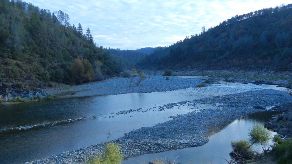
The North Fork of the American River is flowing freely thanks to all this recent rain.

Poison oak is everywhere so beware.


I had not used this section before and it took us all the way back to the starting point near the paid parking.  Shady, pleasant, and good footing.


This is the paid parking.  On the right you pull in and self register.  

The side of the road where you can park for free, or go beyond the gate shown above and park alongside the road there to hike the Bypass Trail.


The original article below is based on a variation of the hike shown above.  There are a multitude of trail choices as you go.  I advise getting GPS tracks or a map of the park trails if you are not familiar with the area and not secure finding your way in new places.
____________________________________________________

COUGAR SIGHTINGS ALERT!Yesterday, March 28th, 2013 a cougar was sighted near the "Y" along the trail.  There is some dense cover for it, so just be aware, be noisy, keep your eyes and ears open!  Bears have been sighted in the area in the past, so again, just be alert.


Distance: 7.2 miles using my GPS tracks, but more or less as you choose options.
Difficulty:  Moderate to Strenuous also based on your choices of using the road or trails more and the speed of your gait.
Elevation Changes:  Over 2400 feet total
Driving Directions: 
  • From Highway 80 East from Sacramento area, take Indian Hill Road east from the Newcastle area.
  • Turn left on Auburn Folsom Road.
  • Turn right on Maidu Drive.
  • You will see China Hill paid parking on the right with a restroom, or you can park along the roadway on the right also.  Walk through the closed park gate to begin the hike using the road as shown on the map below.
Notes:  There is paid parking available, or more recently I have been using Cardiac Hill Trail that is now well marked with park signs.  I park alongside Maidu Road at the gate marked for Cardiac Hill, just before a sign posting the entry to China Bar. There are restrooms at the trailhead posted on the GPS tracks, the icon for a bathroom in a large unused dirt parking area, and another at the car icon called "road end" which refers to an unused dirt road, small parking area. The trail that will take you winding mostly through trees along the river continues from there heading south.  Cardiac Hill is a vigorous hike or jog.  Its almost as steep as Training Hill, but prettier and shadier!


 Some volunteers have placed these small signs along the way to point you in the right direction.  (2016 update:  I did not see these signs anymore, but pretty well marked park signage)

 Going down to the river to rest and eat, maybe get wet, make the hike especially enjoyable for me.


 Some areas of the trails do get quite dry and full of stickers when the hills dry.  Gaiters over your boots or shoes help.  My hiking poles propel me uphill on the steep sections which unfortunately are the return trip!


Below is a graph to show you and give you a better idea of what to expect in elevation changes.

Related Area Hike Links:
ASRA ~ Auburn State Recreation District
BLM ~ Bureau of Land Management
Near Auburn, CA

Peachy Hiker's Table of Contents                                         

Updated March 10, 2016
Updated March 29th, 2013

August 19, 2011

Trinity Alps Coffee Creek Loop

For Amazing Views,

a challenging backpacking trip, and to experience wild back country, this is the place.  Photo bugs will be snap happy here!

We took Monday - Friday to hike this loop.  Including vistas, hikes around the lakes we visited, and just touring interesting areas, we figure we totaled almost 40 miles.  The degree of ascents and descents went from 99% to pretty level.  Yes, really, 99%, but not for long!   Topo map included at bottom of page and a graph of the elevation changes. For GPS tracks click here.


The trail starts at Coffee Creek Road and the follows North Fork Coffee Creek up the canyon, winding, hard packed dirt and was far better maintained than last year.  With a few very short exceptions the trail is fairly easy for about the first five miles or so.  There are a couple of solid bridges along this section, and then a couple of creek crossings that were manageable, this trip, without getting water in my boots (using gaiters).


At one crossing you'll see a campsite straight ahead or the crossing at a 90 degree right turn.  We read there was an enticing flat spot between the creeks ahead, so we opted to go for it.  We didn't find any wide level spot as described so CJ snd I hunted out a small exotic feeling place with a mini-waterfall and large ferns, with easy water supply access.
The next day we headed out for South Fork Lakes.  This sign is at a fork where you head to the right.


Here is where you find the first challenge of any length.  This section follows a narrow creek bed very steeply uphill through an expansive meadow into the woods.  In the forested area, the trail traverses but it's still a steep challenge.  The bright side is that it is wide and you can rest as frequently as you need to catch your breath.


Once you get over the ridge, there is the excellent vista on the right, shown below, with CJ, our graduate!


We caught a glimpse of a lake so we knew we were getting close!  Traverse downward to make it to the first lake with campsites available.


There were grass and willows growing around the edges, and it was a breeding ground for mosquitoes and little black flies that bit!


We chose to hike over to the lower lake (shown above) and what a beauty!  This lake gets few visitors and supposedly has good fishing too.  The campsite we chose was back from the lake which sits in a nice granite bowl.  Directly across from us was a waterfall the full length from the crest to the lake, and snow still was hanging along the sides of the deeply carved crevice the water flowed down.  We couldn't walk all the way around this lake, but had a great time swimming and resting here.  At a glance it looked as though is was just thickly covered with bloodthirsty mosquitoes, but they turned out to be some friendly damselflies, non-biting "fish bait" larger than mosquitoes and smaller than typical dragonflies that hung out in grassier areas around the lake. Firewood was reported to be depleted but we found plenty.


To return to the trail we had to go back to the first lake and wind around the western side. Leaving the South Fork Lakes we went through too great a variety of terrain and trail types to list, but one wonder was going through wet acres of cornflowers almost as tall as ourselves!  Amazingly beautiful!  In places like this the guys would holler out "GO Away Bear!" as if they were boy scouts practicing a drill. 
We hiked toward Wolford Cabin, which we had read was open for use of hikers, and hiked another section of the Pacific Crest Trail.  Across the ridge that lead to the Mavis Lake, PCT, Wolford junction, we enjoyed wide opened views across both sides (photo below).


CJ was in a hurry to get further for some reason, so we abandoned our planned stop at Mavis and went south for the Wolford Cabin. The trail going down to Wolford Cabin was horrendous:


Wood debris was laid thickly and randomly over the ground with difficult and unsafe footing.  At first it was barely visible and damaged from water runoff.  NO real trail left for some distance although we saw equine prints and boot prints here and there.  The trail, as it were, followed the creek down roughly to the meadow the cabin sat romantically situated in.  Well, no more open cabin.  It has gotten too dilapidated for safe use and is locked like a bank vault. There is a campsite set up near the creek, but we opted to move on. Quite a disappointment but remains a real postcard gem!

Wolford Cabin
There are two trails that exit that area.  Our tracks leave uphill at N41 11.748 W122 49.685, starting away from the creek and the other trail is guided beside the creek.  We were moving on to Granite Lake that night and Doe Lake the next day. 

If you  think about side trips to additional lakes, I put waypoints marked as Mavis, Fox Creek Lakes, and Stoddard Lakes.

Onward to Granite Lake for a 12 mile day.


Night fell and we finally made it to Granite Lake but couldn't see much of anything.  Thirsty, tired and hungry, even nauseous, a camper showed us the closest camp...haha.  The photo below shows a widow maker had fallen right over the firepit! (Widow Makers are dead trees that could fall on you and your camp...potentially lethal, really!) Seriously always look for those standing dangerously close before you set up camp! 


Below is the rest area for us that night, Granite Lake:


We found the water mossy.  Our water was obtained with great effort from a slow flowing spring with silty debris, but it was pure.  We could hardly wait to get out by going south then curving west in a giant u-turn which then took us east to Doe Lake.  This was one of the hardest sections we climbed.  The hike was short between the lakes but narrow, washed out, loose surface, and very steep with a drop off down the mountain in the event of a false step. Not for the faint of heart or inexperienced.


Once over the worst, there was still an ascent, but wide, better, safer trail which gave beautiful absorbing views and rest areas.


Above was our favored destination: Doe Lake.  Fish jumped alll over the place.  A fishing rod would have been nice to have!  Snow still lay in blankets on the far side of the large granite bowl, slowly melting into the lake.  But the sun over rode the chill and it was swimmingly refreshing!  Good blocks of sunning rocks for drying out lined one side of the lake.  Camp was far enough away that the mosquitoes were less annoying, but anywhere near the water in the early evening and morning was war!  Several campsites are hidden in the woods, but we escaped having company and got it all to our quiet selves.  Plenty of firewood, practically cut to fit our fire pit!  Pretty wildflowers were abundant this year with all of the melting snow still running off; it made bogs and meadows fresh and colorful.


We hiked out through meadows and manzanita.  From Doe Lake you can take a side trip to Stoddard Lake for a camp or rest, but we again opted for more of a wilderness experience.  Stoddard is accessible by road to boaters and picnickers, is larger, and more populated. The trail we took, East Fork Coffee Creek Trail, becomes rocky and narrow and at times, steep downhills. A few tree fall crossings and creek crossings along with some seeps, through some bogs and meadows, but overall, enjoyable.


Then it opens into an old mining road that lead us down to Coffee Creek Road. From there we hiked up a mile along the dirt road to get to our vehicle. We had an ice chest with cool drinks waiting, rested our weary dogs and congratulated CJ for carrying a heavy backpack, hiking the miles with blisters, and never complaining!!!  He is now initiated into the world of backpacking!  Glad to have shared our passion for the woods with him. 


Hike Difficulty and grades: Strenuous (STEEP areas,see graph, higher elevations harder for "flatlanders", length, technical backpacking skills required over some sections, steep washed out sections, heavy debris sections). Range was up to a 99% grade upward around the 6.6 miles area. Much ranged in the 20%s.
Distance Hiked: 32.98+ miles
Ascent and Descent: 16,858 feet total, per Garmin Basecamp (only including the tracks per GPS, not side trips).
Trail Tread Types: Pine needle covered packed soil, old road width to barely single tread, loose rocks on steep narrow sections, wet and dry stream beds, boggy, very tall thick vegetation to navigate through, rocky, some boulders to step around and/or climb.

For a general idea of this trail location here is a map from Wikiloc to help you locate it and get driving directions to Coffee Creek, CA 96901, from your locale.:

GPS Tracks

For other nearby hikes:
Trinity Alps (near Redding, CA)


·         Trinity Alps Coffee Creek Loop
40
Strenuous
12
Strenuous and Difficult
·         Trinity Alps (Hobo Gulch)
backpack
Strenuous!

Peachy Hiker's Table of Contents

Trails by Locations

Happy Trails!

edited 5-7-2013
Edited 7-2014