


A rewarding intermediate to advanced day hike to the top of the Horsetail Falls in Desolation Wilderness.
* If you click on a photo the photos will be enlarged for better detail. At the bottom of the page you will find driving directions, and other information. No tracks will be posted this time, but a topo map of the area is included.
 |
Horsetail Falls, Desolation Wilderness |
Directions: This spectacular waterfall can be seen from Highway 50. There is a paved parking lot called Pyramid Creek with a small day use fee. It is 6 3/4 miles west of Echo Lake Summit or 1 2/3+ miles northeast of Strawberry.
Distance: One Way: 1.5 miles to the base of the falls and to Avalanche Lake is listed as 1.8 miles according to Desolation Wilderness' website. Other estimates from the base of the hike to the top of the falls are 5.5+ miles one way; go more or less as you like.
"Difficult, and potentially dangerous" miles, even though it is a short distance if you go to the top, but tame along the creek. I love this day hike or backpacking trip, but strongly recommend friends, a plan, and supplies.
At the trail head are flushing toilets and permits for day use into Desolation Wilderness (that means into the steep areas). For backpacking you will need to make arrangements with Pacific Ranger Station at Fresh Pond or online for a permit. Campfire, hunting, fishing, and firearms restrictions and regulations are available at that site, too.
 |
| The trail along Pyramid Creek begins winding through forest and small bushes but a clear trail emerges along the creek. |
 |
Keep your eyes open in this shady area! There may be a rattlesnake along resting in the shade of fallen logs,and I very nearly stepped on this guy! He is a huge grand daddy of a snake and apparently had eaten recently. Lucky for me. |
 |
| I find this hike is rewarding because along the way the creek is cooling, soothing, energizing, and beautiful! There are some fantastic views of Horsetail Falls with many pretty photo opps like this of the water splashing its way through narrow spaces creating that wonderful rushing sound! |
 |
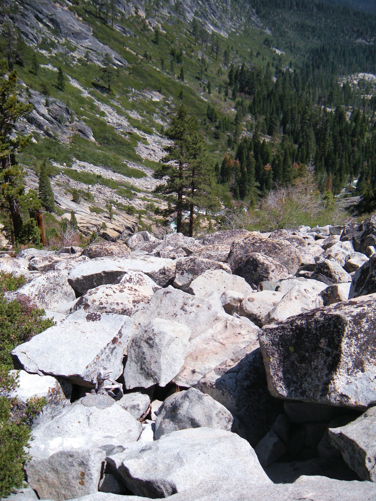
| Here is one of our glimpses up the mountainside of one section of the famous waterfall! If you are going to the summit, you will hike inland for awhile away from the falls, through some tall manzanita, then up some smaller loose rocks and granite tables. If you are there with the kids, there is a viewing area that isn't hazardous and is fun. |


This is that widow maker I mentioned, an excellent landmark.


Another benefit of this hike is the views of the Sierras once you have climbed high enough.
For me it keeps me climbing for more. Some years you can see those covered in snow (notice the ski run remnants to the left?) and even find yourself cutting through some snow on your hike. I've had some fun snowball fights up there!

From this part of the hike you are over the falls, looking down towards them. Just some granite rocks to descend back to being about level with the water.
 |
That's me, Peachy Hiker, climbing westward away from Horsetail Falls. |
 |
| At the top you reach the lakes, Avalanche Lake first. Water all around is inviting on a hot day. Pick a boulder and have some lunch. For a day hike you can just turn around and head down after some photos, lunch, and rest. |


 |
A little further in is this paradise. Beyond this area are some great granite flat spaces for camps, and beautiful views. The bugs come out so be prepared! |
 |
A final parting view of and from the top of Horsetail Falls before veering upward and away from the falls to go back down to the trail head. |
Advisories:
There is not an officially recognized or maintained trail beyond the base of the falls, and isn't for everyone, so no GPS tracks are posted. Sometimes there is some spray paint, and some people have put up cairns, but those are not reliable sources for directions. If you are experienced at bushwhacking and cross country hiking you can navigate this "trail", and if you lose sight of it you can find it a little ways ahead. Having seen our photos will hopefully help you keep track of the "trail" as you go up the left (west) side of the creek.We saw one young lady who had climbed up much too far for her comfort, equipment, and expertise. She was inching down the granite on her seat, looking quite frightened. She didn't have anything like a day pack, water, rope, or other assistance and had gotten separated from her group. She declined assistance. Those are people who may fall to their injury or death.
Have shoes good for granite and boulder scrambling. Take first aid and a rope. I also carry a flashlight and headlamp, a mirror, first aid kit, and rain gear. Take some snacks if not lunch. Go together, not alone, especially if this is a new hike for you. Don't leave your partner assuming they will make it to the top. Patiently assist them and guide them so they are sure where to go. Some areas you can use to get up but not down!
 |
Topo map of Horsetail Falls and Pyramid Creek |
Pacific Ranger District
7887 Highway 50
Pollock Pines, CA 95726-9602
530-644-2349
TTY 530-647-5407
*** Use caution if you climb beyond the official waterfall viewing area. The granite gets steep and can be slippery. Also use caution regarding following cairns (rocks stacked) for guidance as they may misdirect you, or be torn down when you return. People do get injured or lost and is a very difficult place to do a rescue, so I prefer it not be you!!!
Feel free to add any helpful notes for hikers!
|
Desolation
Wilderness
|
|||
|
2015-07
|
10+ miles
|
Strenuous
|
|
|
2014-08
|
30 miles
|
Moderate to Strenuous/Difficult
|
|
|
2014-07
|
18 miles
|
Moderate-Difficult
|
|
|
2014-06
|
12+ miles
|
Moderate to Strenuous
|
|
|
2013-06
|
13+ miles
|
Moderate to Strenuous
|
|
|
2012-09
|
Umpa Lake & Enchanted Pools
|
8+ miles
|
Cross country ~ Moderate
|
|
2012-08
|
Horsetail Falls via Pyramid Creek TH
|
Aprox. 10 miles to lakes at
the top of the falls
|
"Difficult, and potentially
dangerous" miles
|
|
2012-07
|
10 miles
|
Moderate
|
|
|
2012-07
|
8 miles
|
Moderate-Strenuous
|
|
|
2012-06
|
Lyons Lake via Lyons Creek Trail
|
10+ miles
|
Strenuous
|
|
2012-08
|
9.2 miles
|
Moderate
|
|
|
2012-06
|
6+ miles
|
Strenuous
|
|
|
2011-07
|
Lyons Creek Trail with melting snow
|
9+ miles
|
Moderate
|
|
2011-02
|
3.8 miles
|
Moderate
|
|
|
2010-09 We hiked 12 days.
|
167 total
|
Moderate to Strenuous
|
|
Added updated links 06-2016
updated 6-6-2013
updated 6-6-2013
No comments:
Post a Comment
Thank you for your visit to Peachy Hiker's place and for taking the time to share your thoughts!