


Maude Lake, a hike up and across granite,
for a swim, sun, and a fair amount of privacy.

Maude Lake is the destination for this hike but not necessarily the prettiest view. You'll find more solitude here with plenty of room for other hikers and picnickers.
For a more current article for this trail, see Rockbound Trail to Maud, Doris, and Lois Lakes.
Distance: 10.1 miles round trip. You could shave a bit of that off since I went to the opposite side of the lake.
Difficulty: Moderate, basically due to miles, some elevation gained partly by those stairs of granite!
Elevation range: 6739-7685 feet, up going in and down coming out.
Driving directions: Take Highway 50 to Wrights (Lake) Road north from the Kyburz area. The Wrights Lake Road will be between tract 36 and tract 39 along Highway 50. Follow the signs to Wrights Lake Recreational area. When you get to the Wrights Lake Welcome Cabin and parking lot on your left, go straight ahead following signs to Rockbound Trailhead. There is ample parking and a restroom there. (The trailhead is near the restroom.)
Notes: For day hiking, just fill out a free day use permit at the trailhead. For backpacking you can get permits online or at a Tahoe or El Dorado National Forest Ranger Station, for a fee. There are no campfires allowed inside the wilderness boundaries and if you fish, be sure to have your regular fishing license with you.


 |
 |

There are intermittent forested areas with views of distant peaks that I enjoy using as landmarks of my progress.


 |
| Refreshing as it appears, this section through the aspens delights those of us who seek out wildflowers; it also camouflages the ravenous vermin with wings- out to get you, (the dreaded mosquitoes). |
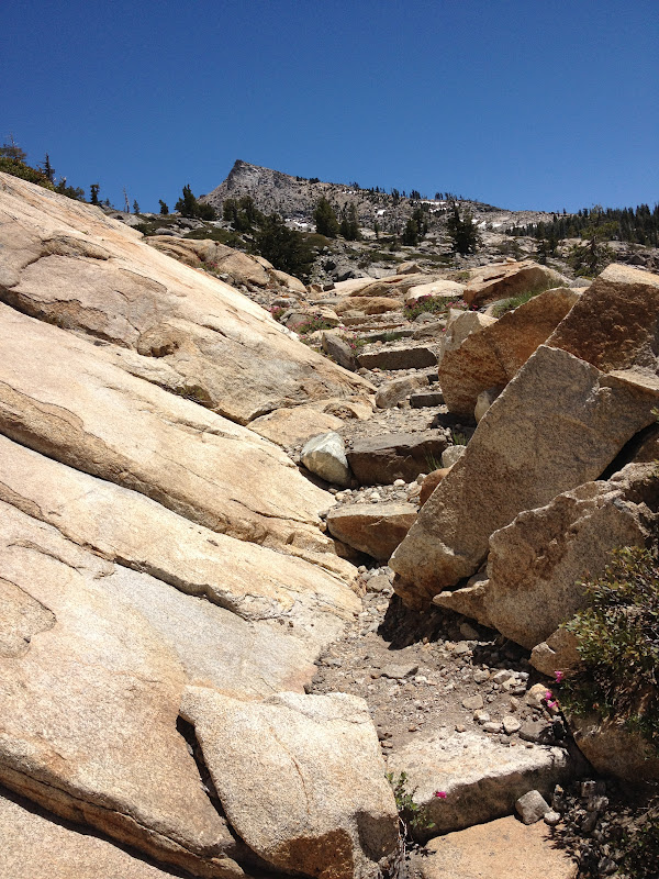
The granite stairs I mentioned will look like this. Some traverse to make a steeper climb easier.
*** Please avoid using cairns (also known as ducks) as guides for safety reasons. People have followed them thinking they were placed for guidance but they've often led hikers to random places other than their destination. If you use cairn building as a guide, you may end up lost because they will be moved or gone when you return. Look for landscape and use your map, GPS, compass, and landmarks to find your way.

 |
| Maude Lake! You have arrived! There is some land mostly surrounded by water that has nice large rocky areas to sit and picnic on, plenty of shade and sun, and on this day, not so many bugs. The water is nice rather than snowy cold. If you follow the trail around the northern side of the lake, there's a large watershed where the trail is built to help hikers stay out of mud using some well designed rock features. |
 |
| Local views all around are relaxing and its a secluded, quiet area. It can be breezy, though refreshingly so. I would backpack here. There are some fish, but their dinner time ripples look small. |
 |
| On my way back I saw this little user trail and needed water for the return hike. I found this welcome mini-waterfall. Resupplied, it was time to return rather than risk night hiking. |


Related Posts
|
Desolation
Wilderness
|
|||
|
2015-07
|
10+ miles
|
Strenuous
|
|
|
2014-08
|
30 miles
|
Moderate to Strenuous/Difficult
|
|
|
2014-07
|
18 miles
|
Moderate-Difficult
|
|
|
2014-06
|
12+ miles
|
Moderate to Strenuous
|
|
|
2013-06
|
13+ miles
|
Moderate to Strenuous
|
|
|
2012-09
|
Umpa Lake & Enchanted Pools
|
8+ miles
|
Cross country ~ Moderate
|
|
2012-08
|
Horsetail Falls via Pyramid Creek TH
|
Aprox. 10 miles to lakes at
the top of the falls
|
"Difficult, and potentially
dangerous" miles
|
|
2012-07
|
10 miles
|
Moderate
|
|
|
2012-07
|
8 miles
|
Moderate-Strenuous
|
|
|
2012-06
|
Lyons Lake via Lyons Creek Trail
|
10+ miles
|
Strenuous
|
|
2012-08
|
9.2 miles
|
Moderate
|
|
|
2012-06
|
6+ miles
|
Strenuous
|
|
|
2011-07
|
Lyons Creek Trail with melting snow
|
9+ miles
|
Moderate
|
|
2011-02
|
3.8 miles
|
Moderate
|
|
|
2010-09 We hiked 12 days.
|
167 total
|
Moderate to Strenuous
|
|
Update links and facts 06-2016
No comments:
Post a Comment
Thank you for your visit to Peachy Hiker's place and for taking the time to share your thoughts!