Trails in Northern California

Trails in Northern California

Leave No Trace!

Visit desovw.org for more information about Desolation Wilderness. Visit Recreation.gov or call 1- 877-444-6777 to make park reservations. Visit Campfire Permits to get a permit online. More about Leave No Trace principles.
Showing posts with label Hikes near Lake Tahoe. Show all posts

September 05, 2018

Freel Peak Summit Routes


   We couldn't find tracks from each approach, or definitive
mileages, so we are giving each of the three options
(besides bushwacking up the south side), a try.

            Only 1 more mile to Freel Peak once you reach this sign!


From High Meadows Parking


I really hate this 3 1/2 mile section.  To think I am hiking about 1/2 way to Star Lake on a gravel road irks me.  Oh!  Note, I have seen two bears on this trail.  Watch your dogs.

DISTANCE: We hiked 19 miles and did not make the summit, missing it again by less than one mile.  I got injured just shy of the Freel Trail, and although we started up the steps, I couldn't safely do them and had an extremely hard time getting back to the car, headlamp-ed out the last few miles of that awful gravel jeep road.
DIRECTIONS: (added for your convenience on Sept 8, 2018) From  Lake Tahoe Blvd, (between Cold Water Brewery and Grill, and Blue Dog Pizza) turn southwest on to Sierra Blvd.  Go 14 short blocks and turn right on Pioneer Trail then left left on High Meadow Trail.  Follow it to the obvious parking.  A gate there is usually closed and you go through it to hike up the gravel jeep road and follow the directions below.
OR from Highway 50 at Meyers, take Pioneer Trail east and in 4 1/2 miles turn right on High Meadow Trail; follow it to the parking.

View from the jeep road from Big Meadows area.


Veer to the right.  This sign should be in place.

We finally got beyond the part of this trek I really do not enjoy and on 
to the trail through the forested area.  

We took fewer photos this trip than usual, 
but I couldn't resist capturing this one!

As you progress, you get these glimpses of Tahoe that 
help me realize, with gratification, our progress 
to Star Lake and Freel Peak.

A nice spot to refill and get some cold water 
and a few minutes rest.

Star Lake seems to jump out of nowhere and offers spots 
around the lake for camping or to take in the views 
and picnic along your way. If you are there without a moon
 at night, the stars are incredible!  
Taken near the TRT and Freel Peak trail converging with 
a big open area to take in views. By now I had rolled my ankle 
for the first time in my life (I thought I must be immune!) 
and had to think that it might affect our hiking time down if the pain got worse.

Right near the Freel Peak trail junction. From here you get 
on the trail (photograph at the of of the article) and start heading 
up to the summit.  A very short distance in and there is an excellent 
big boulder with a table-like top and room to rest and recharge.  
We left most of our gear there to make our final summit attempt.  
Admittedly we discussed turning back here but being stubborn and intrepid, 
we decided to give it a go. My daughter had never done close 
to this many miles in a day and I had to face the prospect 
of getting all the way back to the car with an ankle injury.

We got up a few of those carved boulder stair steps, 
looked at our distance from the summit, and I had to admit 
the injury was making it impossible.  We sadly turned back.  
It was a bit crushing having logged so many miles.  
We made Mt Whitney but couldn't get Freel on our second attempt.  

For hikers who don't like steep areas, this section between 
Freel and Star Lake will be a challenge.  I love getting the shade and views.

Star Lake on our return was a welcome sight.

I became unable to wear my boots for a while so hiked the Meadow section in socks!

DOWNSIDE OF THIS APPROACH: The gravel road really got the best of me and I got quite an arm and abs workout using my poles to stay upright.  That gravel road section is a curse.  Some of it is steep and it is slippery footing at times.  I was extra thankful not to be carrying more than a day pack.


Hiking miles, half the hike to Star Lake from Big Meadows Parking, 
is a sore spot with me.  Literally and figuratively.  
I get away to be away from roads, not to hike them.  Grrrr.
I hiked most of that section coming down 
in my hiking socks due to the foot, knee, ankle pain.
At least we can say we got a nice sunset through the trees.
The end of the tale at this point is that we head-lamped
out the last couple of miles or so. 
At the end of the week, I am still injured and having difficulty with my foot.  I had to call in at work for two days.  I wouldn't mind so much if we had gained Freel.  If you choose that route, best to do it as an over-nighter at Star lake.  (On day 10 I still can't walk normally from the injury so I am anxious for recovery to get back up to the summit trail, along with the thought that my last attempt will be the shortest hike there.)
BENEFIT OF THIS ROUTE: 1. It is long but could be done in a day without injury.  2. You get to see and hang out at Star Lake which is one of my favorite spots around the Tahoe area. 3. The trail is very well marked and easy to follow. 4.  Since you head to Star Lake you can overnight and use it as a basecamp for probably the easiest way to summit Freel, and perhaps the Triple Crown if you are so inclined. 

From Fountain Place Parking 

This was our first attempt and we really enjoyed the hike.  Without using private property we hiked 15 miles but due to our late start we ran out of time and missed achieving the summit by less than one mile. Keep in mind the last mile is the hardest and most time consuming.
 One of my favorite things in life is wildflowers!  We enjoyed hiking alone the creek in lush green, dotted with lots of color from the blooms.


Then we started really heading upward.  I added a lot more photos to this post to help you envision being there yourself and for a little familiarity with the scenes as you go on your quest for the summit.


Okay, we love special trees and I feel compelled to put our 
favorite tree shots in, for us. : )
This trail was pretty straightforward although there was one large open area that we were a little uncertain about so we swung toward the left, or eastward, just knowing that was the general direction of our destination, and made it easily otherwise.  
DISTANCE: We did clock about 15 miles round trip, so it might have been shy of 17 miles to the summit.  It wasn't too steep and was, for me, a beautiful hike I want to do again next season.
DOWNSIDE OF THIS APPROACH: 1.  Mileage. There are shorter routes.  
2. A major downside of using this route, for us, was the mosquito fest along the creek near the trailhead, and with our timing we were there at feeding time!  The wet area was thick with skeeters, in your mouth, eyes, everywhere.  3. We came from out of town, so we arrived too late to summit,because we had a time limit on childcare. The best time to do this is when you are staying in town and can take your time.
BEST ABOUT THIS APPROACH: The bright side was I spent a lot of time photographing the wildflower wonderland. It is a reasonable approach since nothing but the summit is a really fast ascent.  It is easier on your knees and calves.  There was water along the way at two easy spots.  Bonus, more wildflowers.
More photos of our day: 


Partway up the Freel Summit Trail the views were already rewarding!

This is partly what to expect on the Freel summit trail.  Rocky, 
with those carved stone steps partway too.


My daughter at our high point along the Freel summit trail.

From Armstrong Pass Trailhead Parking

Once my foot heals, I will tackle this shorter, very popular trail, and make the summit, or maybe the Triple Crown instead.  It is day 14, and getting better.  Maybe even this coming week?...Doubtful.

July 17, 2018

Mount Rose Summit 10,785' in Humbolt-Toiyabe NF


 A fantastic training hike for Mount Whitney!

360 degree views from the summit.

Hiking Distance: about 10.5 miles  An out and back hike.
Elevation:  The trailhead is at 8915 feet.  The summit is 10,785 feet.
Difficulty: Considered moderate.  No boulder scrambles or creeks with fallen tree crossings although there were wet areas and a creek that was shallow. I loved hiking poles on this one. For some the elevation may make it difficult.
Location of Trailhead: There is a large paved and well marked parking lot on Mount Rose Highway near Incline Village. 
Good to know: No fees.  Dogs allowed. Restrooms recently reported to be closed. Bug repellent is good to have handy.  Wildflowers blooming even at the summit in July! Some water available but suggest purifying all water. No permit required for day hikes.

Galena Falls, the destination for many hikers on this trail.

The trail was easy to follow.
When you head through this lush section, you might want your bug repellent!
Wildflowers in every color were abundant this time of year and lifted my spirits! After the valley meadows, the trail heads into forest and becomes more of a steep workout.
It can feel pretty hot through this short stretch, but there will be more
shade to rest in  up the Mount Rose Summit trail as you persevere!

On either side of the Mount Rose trail you begin to get 
views hinting at the summit's offerings.
The trail leaves the shady forest and leads upward above treeline.

Windswept and cold, the trail lead me to the summit first where indeed the views are satisfying and photogenic!  Across the saddle is the lesser summit with a cozy windbreak and more of the gorgeous views of pretty much everywhere!


FYI There wasn't a summit register.
More Tahoe hikes that may interest you

Tahoe National Forest
2014-07
6+ miles round trip
Moderate (kids do it though)
2012-12
Snowshoeing PCT at Donner’s Castle Pass
9.3 mile loop
Strenuous
2012-12
3.5 miles
Easy
2014-07
1+ miles with many lakes and options
Easy to Moderate
2011-06
5+ miles this trip
Variable
2013-07
Whatever you choose-4 around the lake
Easy, paved most of the way.
2012-11
1 mile each location
Easy
2012-09
Pioneer Trail near Spaulding Lake
Up to 25 miles; I did 5.7
Easy to Moderate
2012-10
Sierra Discovery Trail with Bear Creek Falls
½ mile est. interpretive loop and picnic area
Easy
2012-09
.7 mile loop
Stroller and WC friendly
2012-09
3+ miles out and back
Easy - Moderate
2012-08
6 miles round trip
Easy
2012-08
4 miles
Easy - Moderate
2014-05
Grouse Ridge Glacier Lake Trail Milk and Downey Lakes are closest.
.5+ many optional miles to many lakes, all pretty close to each other!
Easy to Moderate Car camping available near the trailhead.  Also walk in camps at Carr-Feeley TH
2018-07
10.5 miles round trip
Moderate to Strenuous

Happy Trails!

August 02, 2012

Horsetail Falls, Desolation Wilderness

A rewarding intermediate to advanced day hike to the top of the Horsetail Falls in Desolation Wilderness.

* If you click on a photo the photos will be enlarged for better detail. At the bottom of the page you will find driving directions, and other information. No tracks will be posted this time, but a topo map of the area is included.


Horsetail Falls, Desolation Wilderness


Directions: This spectacular waterfall can be seen from Highway 50. There is a paved parking lot called Pyramid Creek with a small day use fee. It is 6 3/4 miles west of Echo Lake Summit or 1 2/3+ miles northeast of Strawberry.
Distance: One Way: 1.5 miles to the base of the falls and to Avalanche Lake is listed as 1.8 miles according to Desolation Wilderness' website. Other estimates from the base of the hike to the top of the falls are 5.5+ miles one way; go more or less as you like.
"Difficult, and potentially dangerous" miles, even though it is a short distance if you go to the top, but tame along the creek. I love this day hike or backpacking trip, but strongly recommend friends, a plan, and supplies.
At the trail head are flushing toilets and permits for day use into Desolation Wilderness (that means into the steep areas).   For backpacking you will need to make arrangements with Pacific Ranger Station at Fresh Pond or online for a permitCampfire, hunting, fishing, and firearms restrictions and regulations are available at that site, too.


The trail along Pyramid Creek begins winding through forest and small bushes
but a clear trail emerges along the creek.
You will hike beside the creek for awhile, through the trees and across some granite with a fairly level trail to follow.  Many hikers come to sit near it and cool off, take some photos and just enjoy the views they can capture of the upper falls cascading down the canyon.

Keep your eyes open in this shady area! There may be a rattlesnake along resting in the shade of fallen logs, 

and I very nearly stepped on this guy! He is a huge grand daddy of a snake and apparently had eaten recently. Lucky for me.


I find this hike is rewarding because along the way the creek is cooling, soothing, energizing, and beautiful! There are some fantastic views of Horsetail Falls with many pretty photo opps like this of the water splashing its way through narrow spaces creating that wonderful rushing sound!


Here is one of our glimpses up the mountainside of one section of the famous waterfall!  If you are going to the summit, you will hike inland for awhile away from the falls, through some tall manzanita, then up some smaller loose rocks and granite tables.  If you are there with the kids, there is a viewing area that isn't hazardous and is fun.


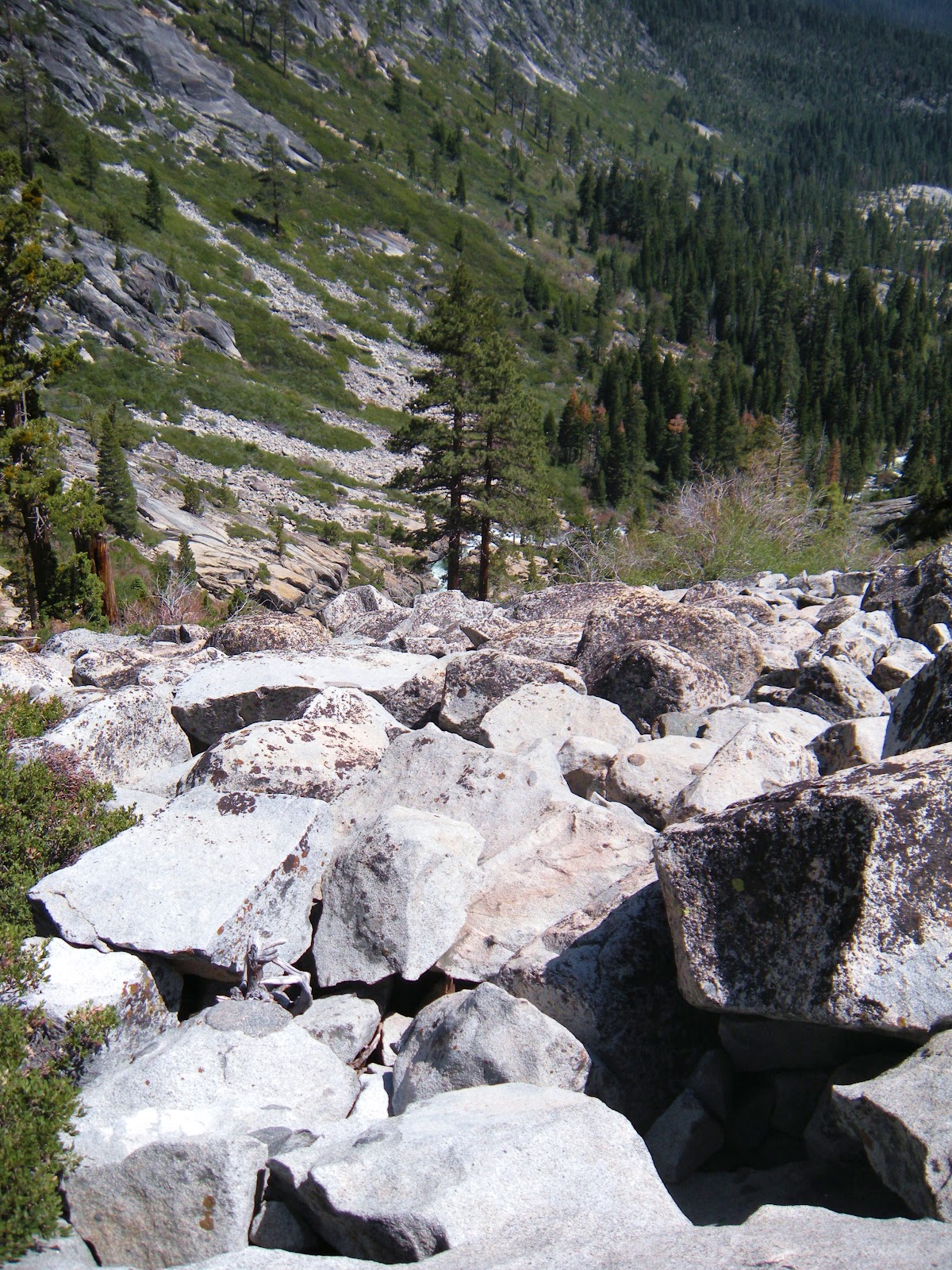
We hike into a short section where we follow a crevice filled with loose rocks and then head right at a huge boulder that can't be missed.  Follow the granite upward keeping your eyes peeled for the widow maker. 
My pet name for this section of the hike is the "Boulder Mine Field".  If you have knee problems, this is the hardest part of the hike.  It feels like an eternity of climbing and even though I do enjoy boulder scrambles, this one is long!  Best wear your knee supports or braces! 

This is that widow maker I mentioned, an excellent landmark.

I keep thinking I am closer and the next view of the falls is still distant!  But keep going for the vistas and the supreme rewards!  It is the most rewarding day hike I have been on.

Another benefit of this hike is the views of the Sierras once you have climbed high enough. 

For me it keeps me climbing for more.  Some years you can see those covered in snow (notice the ski run remnants to the left?) and even find yourself cutting through some snow on your hike.  I've had some fun snowball fights up there!

From this part of the hike you are over the falls, looking down towards them.  Just some granite rocks to descend back to being about level with the water.

That's me, Peachy Hiker, climbing westward away from Horsetail Falls.


At the top you reach the lakes, Avalanche Lake first. Water all around is inviting on a hot day. Pick a boulder and have some lunch. For a day hike you can just turn around and head down after some photos, lunch, and rest. 


Near the top of the falls on our backpacking trip this is a powerful place and sight.

For a backpacking trip, you can find a campsites available near the lakes that are far enough away from the water and not too close to your neighbors.  Be bear-safe with your food and other items.  We bear bagged and had a food canister and no issues.

A little further in is this paradise. Beyond this area are some great granite flat spaces for camps, and beautiful views. The bugs come out so be prepared!


A final parting view of and from the top of Horsetail Falls before veering upward and away from the falls to go back down to the trail head.

 Advisories:

     There is not an officially recognized or maintained trail beyond the base of the falls, and isn't for everyone, so no GPS tracks are posted.  Sometimes there is some spray paint, and some people have put up cairns, but those are not reliable sources for directions.  If you are experienced at bushwhacking and cross country hiking you can navigate this "trail", and if you lose sight of it you can find it a little ways ahead.  Having seen our photos will hopefully help you keep track of the "trail" as you go up the left (west) side of the creek.
    We saw one young lady who had climbed up much too far for her comfort, equipment, and expertise.  She was inching down the granite on her seat, looking quite frightened.  She didn't have anything like a day pack, water, rope, or other assistance and had gotten separated from her group. She declined assistance. Those are people who may fall to their injury or death. 
     Have shoes good for granite and boulder scrambling.  Take first aid and a rope.  I also carry a flashlight and headlamp, a mirror, first aid kit, and rain gear.  Take some snacks if not lunch.  Go together, not alone, especially if this is a new hike for you.  Don't leave your partner assuming they will make it to the top.  Patiently assist them and guide them so they are sure where to go.  Some areas you can use to get up but not down! 

Topo map of Horsetail Falls and Pyramid Creek

Desolation Wilderness Permits
Pacific Ranger District
7887 Highway 50
Pollock Pines, CA 95726-9602
530-644-2349
TTY 530-647-5407
*** Use caution if you climb beyond the official waterfall viewing area.  The granite gets steep and can be slippery.  Also use caution regarding following cairns (rocks stacked) for guidance as they may misdirect you, or be torn down when you return.  People do get injured or lost and is a very difficult place to do a rescue, so I prefer it not be you!!!
Feel free to add any helpful notes for hikers!

Desolation Wilderness
2015-07
10+ miles
Strenuous
2014-08
30 miles
Moderate to Strenuous/Difficult
2014-07
18 miles
Moderate-Difficult
2014-06
12+ miles
Moderate to Strenuous
2013-06
13+ miles
Moderate to Strenuous
2012-09
Umpa Lake & Enchanted Pools
8+ miles
Cross country ~ Moderate
2012-08
Horsetail Falls via Pyramid Creek TH
Aprox.  10 miles to lakes at the top of the falls
"Difficult, and potentially dangerous" miles
2012-07
10 miles
Moderate
2012-07
8 miles
Moderate-Strenuous
2012-06
Lyons Lake via Lyons Creek Trail
10+ miles
Strenuous
2012-08
9.2 miles
Moderate
2012-06
6+ miles
Strenuous
2011-07
Lyons Creek Trail with melting snow
9+ miles
Moderate
2011-02
3.8 miles
Moderate
2010-09 We hiked 12 days.
167 total
Moderate to Strenuous


Happy Trails Again!
Added updated links 06-2016
updated 6-6-2013