Trails in Northern California

Trails in Northern California

Leave No Trace!

Visit desovw.org for more information about Desolation Wilderness. Visit Recreation.gov or call 1- 877-444-6777 to make park reservations. Visit Campfire Permits to get a permit online. More about Leave No Trace principles.

September 26, 2012

Finding Umpa Lake in Desolation Wilderness

A Cross Country Day Hike

A young boy thought this small lake, off the beaten track, should be named "Grampa" but he couldn't pronounce that yet, and actually said, "Umpa", which the park adopted.

Twin Lakes taken in Sept. 2012

Distance: 8.44 miles hiked; tracks are for 6.8 (per Garmin BaseCamp) miles.
Elevation changes: 3135 feet actual climbing and descending. 
Elevation ranges between 6636 to 8134.
Driving Directions:
From Highway 50 near Kyburz, CA turn north onto Wrights Lake Road. Note that the sign I saw only said "Wrights Road". Follow the signs passing Lyons Creek Parking, and Bloodsucker Lake parking, on to Twin Lakes Trailhead parking.
Advisories:  There is a vault toilet at the parking, but not water.  Campfires are not allowed.  Even to use your JetBoil or other cooking device you need your fire permit.  Bring snacks, water, an extra layer for warmth, and me?  I wouldn't do it without a camera.  That's just me!  Swimming at the lakes is also an option.  Wind is not uncommon.

Because it was so beautiful, I have posted more photos than usual.  

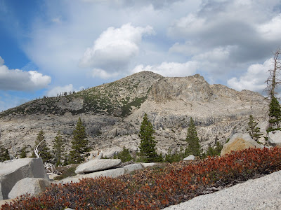
The trip delivered skies with clouds roaming freely from horizon to ranges above, winds playfully unrestrained and cool, then a sunset and sunrise equally rewarding.  Fall colors splashed all around, even in rocky crevices.  It was a photographers play land!

Umpa Lake from the west side looking east to the notch in the saddle leading to Twin Lakes.  Taken in Sept. 2012

     To find the trail, start at the Twin Lakes Trailhead parking lot.  On the northwest, there is a closed forestry gate.  Follow the road a short distance to the trail.  There is a sign pointing the way to the trailhead near Wrights Lake.  When you get to the bridge there is a large forestry sign at which it only takes a minute to fill out the required day use permit (no fees but donations accepted).  Follow the trail to the right, not over the bridge. 
     At the first junction, there is a wooden sign giving directions; take the trail heading eastward, to the right, on a fairly steep uphill section of clearly marked trail.  (My trek was counter clockwise, but either way works, and a map is posted at the bottom of this article, as well as a link for GPS Tracks.)

 You will pass a sign clearly marking the entry into Desolation Wilderness.


The next junction has a easily visible post pointing left to Twin Lakes and right to Grouse Lake.  Follow it left across the open granite where you will head gradually upward.


There are some creek crossings, although at this time of year (September) most are dry or close to it.

There are also unnamed ponds, swimming holes, and a lake. 


As you climb you are treated to some sweeping views of the valley; have your camera ready.
Hikers are also treated to colorful views of the peaks ahead. 
In the spring and summertime the colors are from wildflowers.

If you feel you have lost sight of the trail on the granite, do a visual sweep and most likely you will see the obvious trail marked by rows of rocks, or stacks of large rocks, resume. 

Volunteering  at Twin Lakes western shore.
The trickiest place for me was at Twin Lakes where I read that you cross the saddle on the left (WNW of the lake) going up. From here it is a cross country hike. I had a hard time finding the "trail" since it is just a use trail and is not maintained or marked. It is narrow at first then disappears. To assist your search, I hope my photos help. This lone tree was right on my way up and a hard to miss landmark.
This photo was taken as I reached the top of the saddle.  The tracks I had downloaded led down through the dirt and grasses.  My personal preference is to hike on the granite, so I went down on the right side of the creek bed using the rocks.

Umpa Lake was smaller than I expected, barely a pond! With all the granite

surrounding it, it is a small oasis.

When you get to the top of the saddle, head downward going northwest.  You will see Umpa in the distance below.  It is small, marshy, surrounded by a few trees.  A scenic distant view will open up on the west to as far away as the eye can see!

Looking back up toward Umpa.

I made the loop by hiking cross country downhill to the west, looking for a place to camp in less wind! As the day grew shorter, the wind got a little blustery with me! The pressure was on!  I spotted sparse trees on the southwest but the wind was still more than I wanted to battle overnight and there wasn't a water supply.

I didn't have an exact destination and I ended up camping near Enchanted Pools largest pool. I got there at sunset and quickly set up camp.
I had somehow not packed my headlamp so I didn't want to be searching for things in the dark.  I got water purified, my tent set up, and was eating my dehydrated teryiaki chicken and rice (two servings!).  The moon was bright and dimmed the stars, but created postcard perfect reflections on the pool. 


  Please respect the no fire orders for this reason.  One tiny mistake could forever change the wilderness.
I hiked out going downstream, from one enchanted pool to another pool, each brighter and more beautiful than the one before!


Once I reached the point where the trail leads back up onto the granite and away from the creek, I headed southwest across the granite. 


To the east you won't miss these tall dark cliffs.
You will head back into these woods, already brightly dressed for autumn,
and will meet up with the familiar Twin Lakes/Grouse Lake trail.  From there it is westward to return to the trailhead through the woods.  Fall colors are settling in already, and although the cold temperatures haven't hit, it won't be long.  Take a rain parka at least; I recommend something for a warmer layer.  When you get up higher, the winds sometimes get colder and have nothing to restrain them!

Overnight permits
GPS Tracks


More trails to discover:

Desolation Wilderness
2015-07
10+ miles
Strenuous
2014-08
30 miles
Moderate to Strenuous/Difficult
2014-07
18 miles
Moderate-Difficult
2014-06
12+ miles
Moderate to Strenuous
2013-06
13+ miles
Moderate to Strenuous
2012-09
Umpa Lake & Enchanted Pools
8+ miles
Cross country ~ Moderate
2012-08
Horsetail Falls via Pyramid Creek TH
Aprox.  10 miles to lakes at the top of the falls
"Difficult, and potentially dangerous" miles
2012-07
10 miles
Moderate
2012-07
8 miles
Moderate-Strenuous
2012-06
Lyons Lake via Lyons Creek Trail
10+ miles
Strenuous
2012-08
9.2 miles
Moderate
2012-06
6+ miles
Strenuous
2011-07
Lyons Creek Trail with melting snow
9+ miles
Moderate
2011-02
3.8 miles
Moderate
2010-09 We hiked 12 days.
167 total
Moderate to Strenuous

See the Full Table of Contents.
                                                                                       
                                                                                          Added updated links and Table of Contents 06-2016

 Happy Trails!

September 16, 2012

Hiker Dislocates Shoulder Using Hiking Poles

Hiking Poles and Wrist Strap Safety Issues

True experiences as told to Peach Hiker


I met George and his son Don on my hike from Old Donner to Azalea Lake in August 2012.  We chatted about our experiences and George mentioned to me he thought having my wrists in the provided loops and my hands on the pole grips was not safe.  Haven't most of us been hiking along through some rocky, maybe bushy areas and had our hiking pole get caught between boulders or something?  Generally, we catch ourselves, pull the pole out and continue. 

SHOULD WE USE WRIST STRAPS?

George had his hands through the straps on a hike when one of his poles got tangled in the overgrown brush along the trail.  Apparently he had some momentum going and the felt himself going down.  He thought it best to try to fall pretty flat and let the impact be absorbed by his torso, rather than risk fracturing or injuring his wrists, but with his hand in the pole strap, when he hit the ground being attached to the pole that way caused his shoulder to be dislocated because the pole was jammed and not moving with him.  Those sorts of injuries last some of us for years, leading to arthritis, tendonitis, bursitis, general soreness, and maybe "frozen shoulder".  In that case it could have been worse if he had been close to a cliff or something.


I usually use the straps so that if I were to fall, the pole would remain with me, not fall down some rocky cliff or fly into brush off trail.  And with the thought that I could get my hand on it and use it to pull myself up again.  I also put some weight onto the strap to ease my grip and keep my hands from doing all of the work.

Lots of people don't think trekking poles are for them so I try to carry an extra pair when I take someone on a hike and offer them a try.  It's free that way, and maybe they discover the benefits!  They can be a helpful balancing tool for log crossings or for creek crossings (I wouldn't have fallen in Bear River getting that photo of the waterfall if I had my poles, and a slippery rock sent me for a dip) .
Another place they come in handy for me is going up a steep grade.  For me they help me drive my self upward faster, keep my footing secure, and distribute the work through more of my muscle groups to save my legs from the brunt of it.  When I am crossing granite slabs that are slanted rather steeply, I use my poles to stabalize my balance, too.  When almost bushwhacking on the trail in Ttrinity Alps from Castle Lake to Mount Bradley Lookout, I used my poles extended in front of me to help push the thickly overgrown manzanita away. 
I have yet to find a dissatisfied hiker once they test poles out.

SHOULD WE USE WRIST STRAPS?

 
Another hiker's account was Ken's fall in one of those fun boulder scrambles.  What I refer to as a boulder mine field.  Use the poles to help test rocks ahead for stability.  They help you balance as you step over or around the next boulder, or down into a small crevice between boulders.  Ken had his hands in the pole wrist straps when he stumbled in between boulders and he said it saved him from falling harder because he was able to keep the pole in his hand and leverage his weight during the fall and regain a measure of control.  He did get banged up but nothing broken or sprained.  He advised that in general the straps are helpful.

SHOPPING FOR HIKING POLES:

If you shop for hiking poles, there are some different options to test out.  I prefer suspension.  When you press your weight down on a pole it gives a little.  For me that relieves my wrists from taking all of the abuse.  Some people feel like they are less stable.  It is completely personal preference so try both styles out.

Another option is what material the hand grips are made of.  I loved my cork handles, and I meet hikers who prefer the EVA foam grips.  Me?  They make my hands sweat too much and the grips feel slippery.  I bought tennis handle tape and wrapped my grips with it.  It is comfortable, durable, handles sweat, and is inexpensive! 

Another option is the type of locks the poles offer.  That is another purely personal preference.  Go to a local sporting store and try adjusting sets and find your preference.

Once you have a set, it is up to you to find your hiking-with-poles-style and me?  I change through a hike several times.  Use the poles with the opposite leg; use both forward simultaneoulsy to pull yourself along; or plant them more randomly where it is convenient, or where areas of trail are so simple and easy you need less from your poles and can amble along resting your hands and wrists.  They fold compactly so you can attach them to your pack or carry them in one hand easily too.

My best advice regarding using your poles and avoiding injury is to be alert when you are next to or in harzardous areas so if a pole catches on something you can avoid injury by manuvering yourself and the poles.  Keep your speed in mind.  Be able to stop quickly.  Carry first aid.

Maybe put them away if entanglement is a chronic problem on a section of trail.  I am a huge proponent of poles for overall safety and health benefits.  The few times I leave them in the trunk, I regret it, even for short hikes.  Find your safety measures with these risks in mind. I think we can have both safety and benefits, but risk always exists so stay alert either way!

Happy Trails and thanks for checking in!

September 10, 2012

Pioneer Trail ~ Spaulding Lake / Grouse Ridge Trails 10-25-2012

The historic Pioneer Trail

is 25 miles long with 

   8 trailheads from 5 miles east of Nevada City

to this section that heads from Bowman Road

east to Spaulding Trail, and can be used to connect to

Grouse Ridge trails. 

Update: 10-25-2012   My visit this week found the Sierra Discovery Trail completely covered in snow!  Bowman Road was good but became one lane of slush before I reached the Yuba river bridge, so I had to turn back.  Autumn colors are great and yet, beware, hunters are out!  With proper vehicles, you can drive up there, but not sure the Pioneer Trail is well marked enough to follow.

The snow on October 25th, 2012


 It is beautiful and maintained;

kids can hike this one.

You drive along Bowman Road past the Sierra Discovery Trail parking to a small dirt turnout on the left side of the road.  Looking closely you will see this sign marking the Pioneer Trailhead.  If you get to the South Yuba River crossing, turn around and find the parking turnout. 

39°21’57.97″N, 120°21’57.21″W

 
Head into the woods along an easy to follow trail and it gets cooler, lush,
and in August, fruitful!


At times you can see the river canyon.


The trail does run through private property, so please be respectful and careful. 

At this point you cross Bowman Road and cross the South Yuba River bridge.

On the northeast end of the parking beside the bridge look for the trail marker. 
At this time there are red ribbons flagging the trail too.  It heads northeast, upriver alongside although not always in view of the South Yuba River.
 (Most of the trail is not rocky like this.)
Look for this signage and PG and E warning.


You wind through the forest, avoiding anything too steep by traversing the hillsides. 
Along with occasional views of the river, meadows open up semi-distant views.
Near the junction with Spaulding Trail you get an enjoyable landscape. 
 Keep in mind what time of day it is if you do this as an out and back (as I did),
because as you descend,
the sun will fade earlier than "sunset".
Then this will be your view and warning as it was mine.  I did step over day old bear scat
on my way up so I tried to hustle back before dark.  Along the way make the noise hikers know to make...talking and singing to the bears and creatures to avoid startling anyone. 
Ya, I probably scared a few people, too!
"Rocky" greeted me as I got closer to Bowman Road. 
Distance:  I hiked 5.7 miles but to connect with the junction to Grouse Ridge would be about another .25 miles each way.
Elevation Changes:  Ascent : 984    Descent: 1011  Shown on the graph below.
Difficulty:  Easy keeping in mind some parts are rocky, but no boulder scrambling is involved, no cliff hangers here.  You can make it longer day hike or a backpacking trip.  If that is the case, I might park at the bridge.
Driving Directions:
  • From I-80 take the Yuba Gap exit.  That will take you to Highway 20 toward Nevada City. 
  • Turn right on Bowman Road. 
  • Pass the Sierra Discovery Trail parking (maybe use the restrooms there). 
  • Go to the turnout at the sign I photographed at 39°21’57.97″N, 120°21’57.21″W  Again, if you get to the bridge, turn back and look for the turnout and the trail marker shown above.
 
 
   Thanks for dropping by.  Share the site if you know anyone who might enjoy it.  Your comments are appreciated.  Happy Trails!
 
Other articles you may be interested in:
and
Tahoe National Forest
 updated 10-2012

September 03, 2012

Kid Friendly Trail near Donner: Wheelchair and Stroller Welcome

 Waterfalls, meadows, wildflowers, and a shady hike.

Sierra Discovery Trail 

updated October 2012 for winter conditions, but other material is still posted below..

Families can enjoy taking small children,

even using a dirt friendly stroller!

Wheelchair accessible,

 (maybe with a little help through the winding dirt section).
Near Truckee, in Tahoe National Forest, close to Interstate 80, off of Highway 20 toward Nevada City.
 
SNOW!!!

You can see this little gem by crossing the small bridge
beside the Sierra Discovery Picnic Area. Taken October 2012. 

The parking lot was covered in snow and the trail unmarked at this time. 
A forestry road and a small turnout that takes off to the left of Bowman on your way in. 
It was also a pleasant stop with all of the autumn colors and
enough snow to play in without having to go too far off of the highway.

Farther down the road, in an attempt to get some photos of the South Yuba River, I had to turn back.  It was one lane scattered with snow.  Trucks passed me by, for hunting I assume.  Notably, it is bear and deer hunting season.  But if you are on a drive and need to get out with the kids, even play in the snow, Sierra Discovery was a nice stop.

In regular hiking season conditions:

The Sierra Discovery Trail is well marked with signs
and a large parking on Bowman Road
1/2 mile off of Highway 20. Directions and details below.

This 12 foot waterfall on Bear River

has a large viewing platform with benches for seating. 
This photo was taken late in a dry year,
but  water releases can effect the flow. A better year of rain or
earlier in the season would be best times to go.


At the start of the trail is a

large gazebo with informational posters about

the area, vegetation, wildlife, geology, and history

of the trail including how it was built.

Wheelchair accessible

bathrooms at the trail head. 


This is one of several sitting areas along the way

that is shady and inviting!  Kids will love the waterfall view!


 After crossing a boardwalk through a large meadow,
the trail comes to the river and this wonderful bridge leads to the loop. 

Kids will love it! 

Either direction takes you along the same loop, although the sign says to the right is easier.
Even in August, wildflowers can be found alongside the trail.
Throughout the trail there are informative signs and wonderful views. 
 
 
The instructional signs along the way give insight into the various aspects of these
ecosystems, and can provide teaching moments with the kids.
 

Pondersoa Pines
 
Near the parking and the restrooms is a large picnic area near the "river"
and is situated in an excellent shady area.
 
Distance and Difficulty:  .7 miles of easy trail
Driving Directions: 
  • Take Highway 80. (East from the Sacramento area).

  • Exit at 161 (to Nevada City via Highway 20)

  • Head West on Highway 20, 4.3 miles (pass Lake Spaulding)  to Bowman Lake Road.  Turn right.

  • The parking for the Sierra Discovery Trail is .5 mile up Bowman Lake Road on your left.  If you reach the bridge over South Yuba River, you have gone too far.

For more information: PG and E Recreation Area, (916) 386-5164
and the book:
California Waterfalls  by Ann Marie Brown

*** Pioneer Trail is closeby. Although not for strollers and wheelchairs, kids would enjoy it.

If you continue up Bowman Road, again, before you cross the South Yuba,

there is a dirt turnout on your left with a trail marker at 39°21’57.97″N,

120°21’57.21″W for Pioneer Trail.   

You can park there and hike through a thickly wooded moist area with water runoff creeks and even in summer is cool.  Head northeast on an easy to see single file trail. It will take you out to the bridge.  You may even find some ripe blackberries to snack on. If you choose to keep hiking cross the road, cross the bridge and at the northeastern end of parking you will find another trail marker heading into the woods again and uphill.  I will post on Pioneer Trail soon, but just in case you visit Sierra Discovery Trail and want a little more, this can get you started.

Other articles you may be interested in:


 Happy Trails and thanks for stopping by!             
 11-2012