


See Donner from the Flora Lake hike. Visit snow covered, iced over ponds and lakes. This is a memorable snowshoe experience!
The Sno Park is a great family fun place! Toboggan, build snowmen, make snow angels, and have a snowball toss (with close parking and restrooms)!
 |
| Peachy Hiker on the lake, very well iced over in September 2015. |
Azalea Lake, a frozen beauty queen!
And it is right off I-80 at the Boreal exit!
 |
| Snowing so hard over I-80 we couldn't even see tail lights in 2012. |
Quite a few of my photos are not showing any longer. Not sure why so I am editing those out today (Aug 28, 2015). I will go for replacements this winter assuming we get snow! For now and ease in updating, I am leaving the captions. Sorry for the difficulty! This link still has all of the photos: GPS tracks
Along your way are creeks to cross, views to take in,
and photographs waiting to be taken. Great backpacking destination!
- Distance: Posted is out and back totaling about 3.5 miles.
- Difficulty: Easy+ at this time. Nothing steep. Conditions can change quickly so check forestry sources if you are concerned.

Now let's get you going!
Advisories:
- Get a sno park permit at the hotel before you park. (Better yet pick one up from stores like REI in town!)
- There are restrooms in the parking area.
- It is snowplowed.
- The trailhead is marked with a billboard at the eastern side of parking.
- You can download tracks to the route from the Old Donner Highway side. My article for that section is Old Donner Pass to Azalea Lake Loop. I have not traveled it in snow.
- Carry food, and plenty of layers. Be prepared for all weather. We encountered rain, snow and sleet. It got windy and colder late in the afternoon.
*** Find GPS links and a map at the end of this article!
(Missing image) In the snow, Everything had a mystical aura.
 |
| The Sno Park is likely to be full of families playing in the snow and building snowmen. |
Gaiters helped me stay dry.
 |
| It appears that there is a seasonal Interpretive Loop. |
(Missing image) The first large icy pond beside the trail.


If you like this article, please share it by clicking on the buttons for social media below for your convenience!
Thanks again!

Looking back at our snowshoeing path!

The photos, despite all looking quite grey, are really in color!

Haha...We headed toward PCT and Donner. Sometimes I got ahead of myself and
landed on my knees by clipping the back of one snowshoe with the other.
Take your time...
landed on my knees by clipping the back of one snowshoe with the other.
Take your time...
(Missing image)
If you stay on the PCT you will see markers on trees. This route breaks off of
the PCT to get to the lakes, so this is the only one you should see on this trek.
Good insulation kept me warm, but I did
have to change layers on our way back.
I carried my usual safety supplies and first aid kit
but was so engrossed in the trip and
achieving our goals, I forgot I had a rain poncho.
It could have been used over my daypack in the heavy moisture!
We were snowshoeing in a storm.
have to change layers on our way back.
I carried my usual safety supplies and first aid kit
but was so engrossed in the trip and
achieving our goals, I forgot I had a rain poncho.
It could have been used over my daypack in the heavy moisture!
We were snowshoeing in a storm.
(Missing image) Flora Lake, inviting and picturesque.
(Missing image) We could see Donner Lake from here but it feels like a "Where's Waldo?" view!
(It is near the center in the "v" between the dark hill and the snowy one.)
We each had our poles broken on this trip...wow. My new set is ordered, but what a
strange problem. From reading, the aluminum poles are stronger (slightly heavier) but
what good is it to carry out the weight of broken carbon poles and do without any benefit? My
new set has my coveted cork material handgrips, soft wrist straps and a locking mechanism.
strange problem. From reading, the aluminum poles are stronger (slightly heavier) but
what good is it to carry out the weight of broken carbon poles and do without any benefit? My
new set has my coveted cork material handgrips, soft wrist straps and a locking mechanism.
(Missing image) The storm wasn't taking breaks at high elevation.

This creek usually has water, but creeklets were pouring under the snow. It took some
searching to find places to cross. Use caution.
searching to find places to cross. Use caution.
(Missing image) Donner Lake is in the "V" behind the tallest sparse tree.

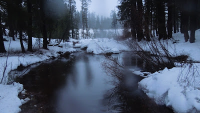
Approaching one of the unnamed lakes and ponds that are all iced over.

Iced over pond. I wouldn't recommend
stepping on any of it.
(Missing image) Bridge to civilization and a weather break.

Almost back to the car! Photographed from the bridge. The blur is snow.
I highly recommend this trail for snowshoeing!!!
I highly recommend this trail for snowshoeing!!!

The trail in red is what I posted for GPS tracks from this snowshoeing trip. Our side trips
are edited out. GPS tracks supplied are accurate regarding areas where we had to detour
due to trail conditions, and may diverge from what a forestry map shows, or maybe from
conditions when you arrive.
are edited out. GPS tracks supplied are accurate regarding areas where we had to detour
due to trail conditions, and may diverge from what a forestry map shows, or maybe from
conditions when you arrive.
The pink trail is one I hike from the Old Donner highway (the brown line) during dry seasons, but is included for your frame of reference. (Posted on Wikiloc) I would still like to snowshoe
all of that from Old Donner Highway to I-80.
all of that from Old Donner Highway to I-80.
On January 5th, my daughter in law, Kristin, and I went up and below is our map of tracks. We followed snowshoers tracks mostly, but blazed our own tracks east and just beyond Flora Lake to our Donner view lunch spot, perfect for a great view on a sunny day!
Reviews of other trails in Northern California: Trails By Locations
Or: By Titles
-
Thank you for dropping by! Happy Trails!
Thanks again!
updated 12-14-2012
updated 8-28-2015
updated by adding the standing on lake photo and rearranging the Advisories text 1-4-2016
updated 8-28-2015
updated by adding the standing on lake photo and rearranging the Advisories text 1-4-2016
No comments:
Post a Comment
Thank you for your visit to Peachy Hiker's place and for taking the time to share your thoughts!