Trails in Northern California

Trails in Northern California

Leave No Trace!

Visit desovw.org for more information about Desolation Wilderness. Visit Recreation.gov or call 1- 877-444-6777 to make park reservations. Visit Campfire Permits to get a permit online. More about Leave No Trace principles.
Showing posts with label Rockbound Trail. Show all posts

July 26, 2014

Rockbound Trail to Lois, Doris, and Maude Lakes in Desolation Wilderness

Be prepared to hike over Rockbound Pass 

to enjoy secluded lakes and numerous wildflowers.


Once you cross the pass, your effort is rewarded.  Hiking down into this valley 
is a green and pleasant stretch of trail to Doris Lakes.

Doris Lakes July 2014
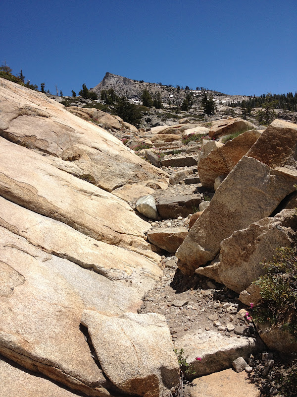
The creek bed east of Doris Lakes crossing Rockbound Trail, July 2014.
For more information provided by Desolation Volunteers
 in planing your trip, check this helpful guide.

Distances:  Official distances are listed on the  Desolation Volunteers website.  My estimations without side trips: One Way:   Maud Lake:  5+       Doris Lakes:  6+      Lois Lake:  9+
Desolation Wilderness is located west of Lake Tahoe near Wright's Lake Recreation Area.
and Icehouse.  It has numerous lakes, and hiking/backpacking opportunities.
GPS tracks on Wikiloc.
Difficulty:  Moderately strenuous, but consider whether you are carrying a backpack,
 if you feel comfortable hiking with a fairly steep view below you (qualifies a trail as difficult
 in my scale of ratings), and whether the rocky trail shown above might inhibit you! 
(Hiking down was pretty fast and easy.)  Up 8590 and down 7064 feet elevation per Wikiloc.

Click and enlarge this photo, keeping in mind how hard it is
to capture "steepness" in a photo!

Driving Directions:  Take Highway 50 to Wrights (Lake) Road north from the Kyburz area.  The Wrights Lake Road will be between tract 36 and tract 39 along Highway 50.  Follow the signs to Wrights Lake Recreational area.  When you get to the Wrights Lake Welcome Cabin and parking lot on your left, go straight ahead following signs to Rockbound Trailhead.  There is ample parking and a restroom there.  (The trailhead is near the restroom.)

Advisories:  Carry water!  If you go earlier in the hiking season, check road conditions. Be aware that there is a lot of uphill, and the "stairs" can wear on your quads and knees. If you have had knee trouble, carry knee supports. 
Desolation Wilderness passes are required.  Day Passes are available at the trailhead signs seasonally, otherwise check in at Pacific Ranger Station at Fresh Pond, CA.


For backpacking, get permits online or at a Tahoe or El Dorado National Forest Ranger Station, for a small fee.  If you are concerned about this trail, talk to the staff at Pacific Ranger Station at Fresh Pond.  There are no campfires allowed inside the wilderness boundaries and if you fish, be sure to have your regular fishing license with you.

Maud Lake 2012
Maud Lake 2012
The first stop will be Maud Lake that is very grassy.  There are some great rocky areas 
to rest on and you can get your feet wet (or swim) and enjoy some shade 
before you start the upward jaunt over Rockbound Pass.

Maud lake 2014
The article Rockbound to Maud has a great detailed description of the trail up to this lake.

Once you have had your rest, follow the trail eastward.  It will head through some thick and pretty vegetation. The trail then begins the upward trend, and will traverse along the north wall, with a gradual incline.  The challenges are the loose rocky surface and the view below.  


There are a few places where you can take off your pack and rest. 
 While you're at it, take in the views toward the west.

In the center is Maud Lake!!!

When you cross the saddle you will see Doris Lakes at the other side.  The hike down is 
pleasant after all of those rocks!  There are "stair steps" down, with all the green and the 
promised lakes in sight were a motivating factor for me.  


As you pass the Doris Lakes, you cross the creek on the far side,where 
you get another magnificent show of wildflowers! To stop at Doris, just hike from 
the trail over to the lake when you are near it.  The trail does not ever go directly to it.


After leaving sight of Doris Lakes, the trail heads north and is hard packed dirt.  It heads into the woods with little elevation change.  On the right you pass an unnamed pond (has a potential campsite on the east side).  The trail stays pretty far to the south west of the pond and suddenly you'll see 
Lois Lake! The path turns rocky again.  


 The campsites at Lois were in the woods on the north side of the lake.The trail is 
packed dirt again, with a nice forest floor for your tent.


I actually saw some snow up there!  This lake has a great "swimming hole" reputation.  
From the shore are smooth rocks and it is easy to wade in.

 Garmin's elevation profile gives you a hint at the climb, but it is a traverse, not straight up climb.


I carry a small pocket-sized map like this, from Basecamp, on my hikes,
which gives me an overview of the area I am hiking in, and to.


Related Posts you might be interested in for nearby trails:

Desolation Wilderness
2015-07
10+ miles
Strenuous
2014-08
30 miles
Moderate to Strenuous/Difficult
2014-07
18 miles
Moderate-Difficult
2014-06
12+ miles
Moderate to Strenuous
2013-06
13+ miles
Moderate to Strenuous
2012-09
Umpa Lake & Enchanted Pools
8+ miles
Cross country ~ Moderate
2012-08
Horsetail Falls via Pyramid Creek TH
Aprox.  10 miles to lakes at the top of the falls
"Difficult, and potentially dangerous" miles
2012-07
10 miles
Moderate
2012-07
8 miles
Moderate-Strenuous
2012-06
Lyons Lake via Lyons Creek Trail
10+ miles
Strenuous
2012-08
9.2 miles
Moderate
2012-06
6+ miles
Strenuous
2011-07
Lyons Creek Trail with melting snow
9+ miles
Moderate
2011-02
3.8 miles
Moderate
2010-09 We hiked 12 days.
167 total
Moderate to Strenuous

See the Full Table of Contents.
Added updated links and Table of Contents 06-2016
Happy Trails!

July 08, 2012

Rockbound Trail to Maude Lake in Desolation Wilderness

Maude Lake, a hike up and across granite,
 for a swim, sun, and a fair amount of privacy.


 Maude Lake is the destination for this hike but not necessarily the prettiest view.  You'll find more solitude here with plenty of room for other hikers and picnickers.

For a more current article for this trail, see Rockbound Trail to Maud, Doris, and Lois Lakes.

Distance: 10.1 miles round trip.  You could shave a bit of that off since I went to the opposite side of the lake.
Difficulty:  Moderate, basically due to miles, some elevation gained partly by those stairs of granite!
Elevation range:  6739-7685  feet, up going in and down coming out.
Driving directions:  Take Highway 50 to Wrights (Lake) Road north from the Kyburz area.  The Wrights Lake Road will be between tract 36 and tract 39 along Highway 50.  Follow the signs to Wrights Lake Recreational area.  When you get to the Wrights Lake Welcome Cabin and parking lot on your left, go straight ahead following signs to Rockbound Trailhead.  There is ample parking and a restroom there.  (The trailhead is near the restroom.)
Notes: For day hiking, just fill out a free day use permit at the trailhead.  For backpacking you can get permits online or at a Tahoe or El Dorado National Forest Ranger Station, for a fee.  There are no campfires allowed inside the wilderness boundaries and if you fish, be sure to have your regular fishing license with you.

 
The trail heads into the forest, nice and shady with generous doses of mosquito action you've come to expect!  The trail passes by some pretty and inviting lake views, through some aspens, quite a bit of shady forest, and finally out on less sheltered granite.

 But notice the trees, they are always close enough.


 I find plenty of shady spots for rests and snacks, but even on the granite shade allures the skeeters!

 In July there are plenty of wildflowers cheering the hiker onward and soon to be upward.


There are intermittent forested areas with views of distant peaks that I enjoy using as landmarks of my progress.

I only cross this stream which was shallow on this trip, and easy enough to rock hop across, although water volume can always change, so be prepared.

As you can see, the Rockbound Trail across the giant slabs is defined by a row of larger rocks on each side.

Refreshing as it appears, this section through the aspens delights those of us who seek out wildflowers; it also camouflages the ravenous vermin with wings- out to get you, (the dreaded mosquitoes).

 The granite stairs I mentioned will look like this.  Some traverse to make a steeper climb easier.

*** Please avoid using cairns (also known as ducks) as guides for safety reasons.  People have followed them thinking they were placed for guidance but they've often led hikers to random places other than their destination.  If you use cairn building as a guide, you may end up lost because they will be moved or gone when you return.  Look for landscape and use your map, GPS, compass, and landmarks to find your way.

At this point you are entering the higher views with more foliage and realize you must almost be there.  Climb some short traversing "stairs" and amble through low growing shrubs. The rocky trail may seem obscure for a moment or two, but look carefully around and you'll find the stairs and rocks guiding you upward.

Maude Lake!  You have arrived!  There is some land mostly surrounded by water that has nice large rocky areas to sit and picnic on, plenty of shade and sun, and on this day, not so many bugs.  The water is nice rather than snowy cold.  If you follow the trail around the northern side of the lake, there's a large watershed where the trail is built to help hikers stay out of mud using some well designed rock features. 
Local views all around are relaxing and its a secluded, quiet area.  It can be breezy, though refreshingly so.  I would backpack here.  There are some fish, but their dinner time ripples look small.
On my way back I saw this little user trail and needed water for the return hike.  I found this welcome mini-waterfall.  Resupplied, it was time to return rather than risk night hiking.
The views looking back are some little rewards for me, reminders of my hikes up and how close I am to the "holy grail", as my car is affectionately known, at the end of long hiking and trail work days.  My pleasure is an ice chest in my car with food and cold drinks for the ride home (hours for me).

Beauty Lake whispers that I'm almost back, and a little regret of sorts always goes along with my anticipation of completing a destination goal.

Nearing the end,  I'm surprised by a hen gathering her chicks!   


Related Posts
Desolation Wilderness
2015-07
10+ miles
Strenuous
2014-08
30 miles
Moderate to Strenuous/Difficult
2014-07
18 miles
Moderate-Difficult
2014-06
12+ miles
Moderate to Strenuous
2013-06
13+ miles
Moderate to Strenuous
2012-09
Umpa Lake & Enchanted Pools
8+ miles
Cross country ~ Moderate
2012-08
Horsetail Falls via Pyramid Creek TH
Aprox.  10 miles to lakes at the top of the falls
"Difficult, and potentially dangerous" miles
2012-07
10 miles
Moderate
2012-07
8 miles
Moderate-Strenuous
2012-06
Lyons Lake via Lyons Creek Trail
10+ miles
Strenuous
2012-08
9.2 miles
Moderate
2012-06
6+ miles
Strenuous
2011-07
Lyons Creek Trail with melting snow
9+ miles
Moderate
2011-02
3.8 miles
Moderate
2010-09 We hiked 12 days.
167 total
Moderate to Strenuous
Happy Trails!  Thanks for dropping by!

Update links and facts 06-2016