For Johntown and Dutch Creek Waterfalls GPS, maps, and more thorough information, click here.
Upper Dutch Falls on Sept 30, 2012. |
 |
| The affectionately named "Ancient Lady" southwest of the Upper Dutch Falls 9-2012. |
The top of Johntown Falls 9-2012 |
 |
| Take water with you as there is none very appealing to try to purify! |
In spring, here is what you may have to look forward to if we can get some volunteers to work on the trail:
The photo below is Johntown Falls at Coloma, CA. photographed by this blogger who lead this hiking day with a Meetup.com. hiking club. The falls were glorious and the hikers equally enjoyable! Weather was warm and mild, the water flow was gorgeous, and the company exquisite!
A walk in the park, so to speak.

This is one of our feisty hikers...none too intimidated as the trail
becomes more rugged and less park-like.

These are more of our fantastic group with high spirits for the day, waiting to see what is in store.

Some took this side trail down to see the Lower Dutch Creek Falls that sometimes forms two separate falls, side by side, that are dropping around, guessing here, 10 feet. At about this time, one of our hikers got hurt, and that makes this a good time to advise good hiking shoes, and for hikers to beware of the short steeper sections of this trail. It is not maintained in any way, and you'll find yourself having to go over or around obstacles like rock outcroppings or tree falls. I might as well mention there is poison oak around here too. At some times of the year it is leafless, so be careful what you grab. Stay on trail and I don't recommend shorts or short sleeves if you are allergic.

When we reached Dutch Creek Falls and Johntown Creek Falls some members took a nice break, while the group I affectionately call the "Bushwhacking Maniacs" climbed higher and closer to the falls and then on up to overlook both falls from as high as we could get.

The trail to the falls is narrow, occasionally steep, but good solid tread, and do-able. For people thrown off by viewing a steep hillside from a narrow path, this might just be too scary.


These are Bushwhackers getting closer to the falls.

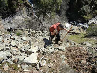
Following a few minutes photographing and enjoying the falls' spray, we headed UP through loose rock, through dry weeds and stickers, over boulders, to the top!
 Look, no hands! Another hint. Watch and listen for rattlesnakes.
This is the top of Johntown Creek Falls; the first photograph on this entry is the same falls.

From the top, we had excellent views of the entire Dutch Creek Falls.
It was worth every sticker I brought home!

Here is the view downstream of both falls. Can you find all the poison oak?
Again, take precautions because it IS there!

Here are your blog writer and photographer with a fellow bushwhacker who wore, note, motorcycle pants on this adventure!
Some photos included courtesy of our hiking club members.
This was a most excellent day!Directions:
- Go to Coloma on CA 49 between I-80 and Highway 50; pay for parking at the parking lot kiosk.
- Walk over the one lane bridge. (You can't miss it as the town is VERY small.)
- Turn right on Bayne and follow the paved road to the locked green gate on the left across from the house downhill by the river. It is also identifiable by small signs like rattlesnake warnings, says "State Park", and is a regular locked forestry green gate you climb over or through.
- The trail is single file, but visible.
Latitude: 38-47'57'' N
Longitude: 120-52'54'' W
Thank you for checking in! There is another review of this hike on this blog dated April of 2010, and has some other information, and beautiful photos showing the differences you can come across. Peachy Hiker's Table of Contents Dutch Creek Trail in June 2013
updated 6-2013 with photos and cautions!


Hi Laura! Sammie's Friends Animal Shelter's correct phone # is 530-471-5041--Thanks for posting the photos of Georgie! Hope it helps to find him a great home with outdoorsy-type people who will love him!!
ReplyDeleteCyd
BTW, great to meet you today---maybe we'll cross trails again sometime with another fur baby looking for a good home from Sammie's Friends (Grass Valley)!!
DeleteCyd, Timing was great! I had planned on being there earlier and would have missed you and Georgie. Keep in touch, especially when he finds a home so we can add a happy ending to this entry! Oh, and I always post new entry links to Facebook for more exposure. http://peachyhiker.blogspot.com/2013/06/a-hikers-best-friend-is-waiting-for.html Thank you!
ReplyDelete