Trails in Northern California

Trails in Northern California

Leave No Trace!

Visit desovw.org for more information about Desolation Wilderness. Visit Recreation.gov or call 1- 877-444-6777 to make park reservations. Visit Campfire Permits to get a permit online. More about Leave No Trace principles.

June 17, 2010

Trinity Alps

Trinity Alps Backpacking June 2010


We chose this trip to upgrade our skills and fitness levels. I've seen photographs, read blogs and trail reviews about the Trinity Alps which planted visions of sugarplums in my head about what it would be like. The weather turned on us a bit and the Forestry informed us most of the lakes are inaccessible from snow and trail damages, and they are as much as 90% iced over! It is mid-June!!!


Furthermore, most of the trails are unmaintained due to a huge shortfall of funding so climbing over fallen trees and crossing swollen creeks that were unpredictable from one hour to the next. Many trails have become impassable due to lack of travel and maintenance. With the worst and best cases presented to us, we took our maps and GPS and made a run for it.

The trail head we chose was an hour drive up a dirt road, with a conveniently located campground very nearby. As the day grew short, we decided to do an over-nighter there then start out refreshed and organized in the morning.


The camp was secluded, a mile down a narrow dirt road; we were there on a weeknight anyway, with recent stormy weather, and with rain forecast for the next couple of days. Not all brochure ads for drawing crowds! So we did have the area almost entirely to ourselves.


A runoff creek tumbled over mossy rocks alongside our chosen campsite giving us easy access and a nice stereo effect from that and the river. A small trail wandered uphill beside it and made a pleasant evening walk. We also walked up the dirt road to the trail head to take a peek.


Along the way was an old wood building, looked like it could house a couple of pack animals, and a nearby old "outhouse" of sorts. There was a great sawed out bench seat and a fire pit.

We meandered further up the road, checking out the scenery and vegetation, and stretching
our legs from the drive. So far, the weather was holding out for us.

We set up camp, finally deciding to use the rain fly just in case, and kept most of our gear in our
vehicle. They say "Early to Bed", and so we were! Yes, the rain came through and our insurance of having the rain fly paid off! In the morning, the ground was only damp, and the air was warmer thanks to the clouds. Breakfast was oatmeal, as usual, for an energy boost! And of course we indulged in our personal luxury, COFFEE! Not powder, brewed! Ah, cowboys knew how to do it!
We did spend some time reading the trail head signs and checking out our options at the map there, counted creek and river crossings and tried to minimize those due to advice from the forestry. We made a plan and after the obligatory first photos, we stepped off into the woodlands, lazy, excited, anxious, and determined. Prepared for almost anything! From there it becomes self hypnotic for me, one foot in front of the other, listen, look around for photo opportunities, and keep pressing on at a steady pace.

Our first creek crossing was small, but an exciting gateway into the alps, and into our fantasies of what we would be able to see.
The trail of course diverged and left us wondering where to go...up, up, up? To the right but only 5 or 6 miles? or to the unknown left that we thought might be the trail to the lake we hoped to get to. We turned left and hiked through a thickly forested area, fire bitten in the last few years, but recovering well.

This is me returning on a trail that is supposedly in good condition, but we hiked a section without our gear to see how it looked...where are my trekking poles and a rope?!?!?! No wait! A parachute!


Wildflowers dotted wet areas, and even bamboo grew around one of the creek areas. It seemed to me the creeks were growing and I found us looking for logs to cross or bigger, less slippery rocks, doing a little bushwhacking (or we were on untraveled and unmaintained old trails) searching for better, safer routes. We found a great log crossing and several of our efforts to reroute ourselves proved unfruitful so we backtracked.

Finally, the great challenge we were forewarned about...the river. We could COULD cross there, but there was one fairly deep area with a swift current. Now that was okay, but what about a sunny day (it was raining just then) or how the rain would effect the melt and runoff had to be considered too. At that point we weren't even sure that to get to our destination, this was the best or only route. Deliberation lasted about 45 minutes, and we tried the high road of unused but visible trail on our side of the river but up higher along the canyon walls. LOTS of tree falls made it difficult, but also allowed great backpack rests here and there. We took a break and contemplated our options again, and studied maps again. Meanwhile, we ate and got some electrolytes in us to prepare for whatever challenge we took. We finally decided to return to the Up up up trail we left behind and give it a try, thinking it may get us closer to the lake. We backtracked. There it loomed. Up. So we climbed. The further we went it seemed like this may have been where we should have gone all along.
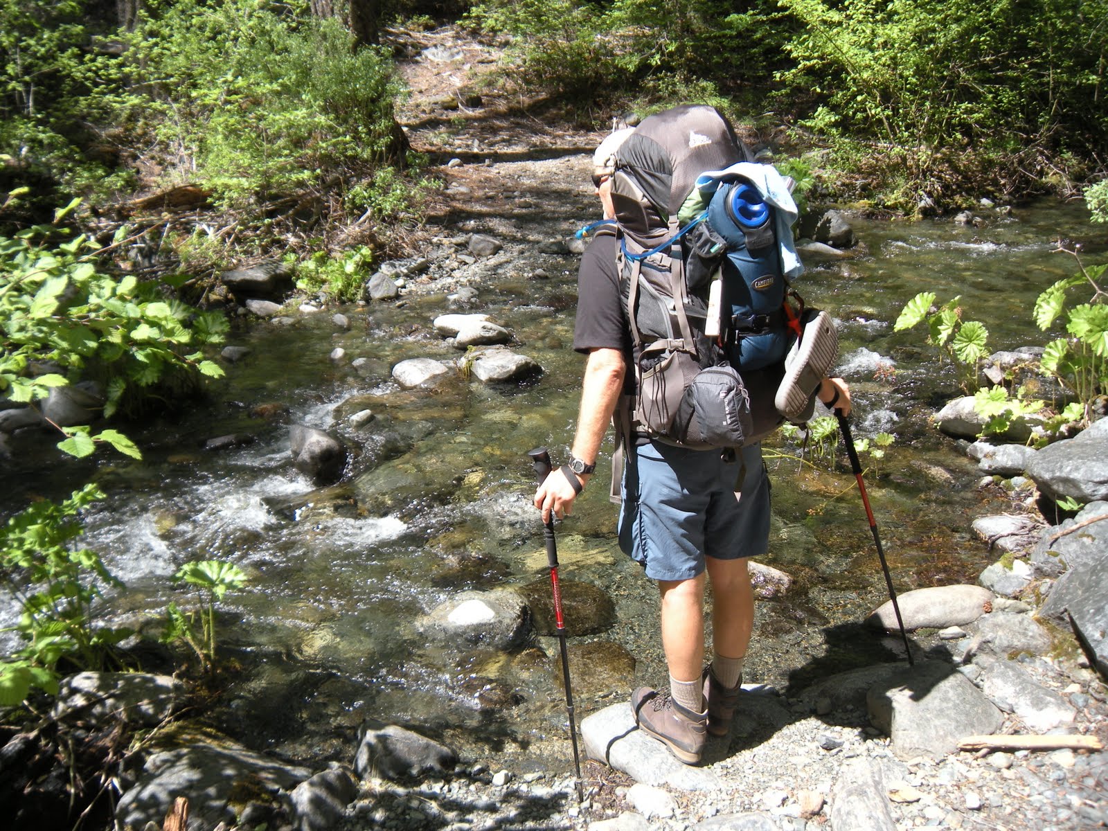
We were able to log many more miles back this way with less dangerous creek crossings and found a camp at a trail junction called Rattlesnake Camp. Quietly nearby were some other backpackers, well hidden, and two more passed us later in the day after we had settled in. The next day was enjoyable, and our bear canister and food bag we had hung were both untouched. Our ritual of cowboy coffee got us off to a great start and after a nutritious dehydrated meal, we made it back onto the trail.


At long last we "car-camped" in Hobo Gulch Campground, with a table, fire pit, the river just across the way, and deer wandering through to the river. We waded in the river, played with a little sunning snake, and took in a little sun ourselves. That evening we had fun watching the deer pass through and we played our camera games capturing Ken's knees, then feet, and close ups of the tent netting, my ridiculous expressions, ...arm pits, you know, good old fashioned fun! It gave us the day to relax and review the funny things, options we could have taken, food issues, future packing ideas, and get our things and selves organized before returning to city life!

Peachy Hiker's Table of Contents

June 03, 2010

Traverse Falls, CA


This is a MUST DO HIKE near Georgetown, CA.  

Distance:  about 3 miles out and back.
Elevation:  1634-2246 feet
Difficulty:  Short hike, but I would rate it difficult due to the steep areas and the ropes and metal cable used for descending and climbing.  Gloves on a hot day help your grip on the cable.
Driving Directions:  Take Traverse Creek Road east off of Highway 193, between Porter Ranch Road and Red Berry Hill Lane, southeast of Georgetown.  Follow Traverse Creek Road staying to the left at Spanish Flat Road.  The creek will run along the east side of the road.  When you see the small creek bridge ahead of you, there's a small confluence of two creeks.  Park by the side of the road.  The trail will head south east of the road and seems to go away from the creek.  There is a photo of the map at the bottom of this article.
Advisories:  This hike is fun but is steep in a couple of places, again, requiring rope or cable for safety.  The ground is often dry hard packed dirt with little if anything to grip your feet onto.  The other note is if you are sensitive to poison oak, this is not the hike for you.  It is every bit as lush and beautiful as could be and pretty toxic for the allergic.  You don't have to creek cross if you are choosing to play at the bottom of the falls.  The pool is absolutely wonderful for swimming.  I cannot imagine taking children here.


The trail was utterly and completely deceiving at the beginning. We parked on the side of the road and the trail lead near the creek through a small field and then through some brush. We even felt idyllic walking through eye level yellow blossoms toward a woods, envisioning a wonderful waterfall with a cool deep inviting pool at its base.


 Quickly, the trail took on rocky, wet crossings and many undulations with steeper qualities. It was enjoyable going through the woods, fully surrounded by poison oak, glossy, full, thick and beautiful foliage! We found the changes pleasant, then arrived at the first anchored rope to assist a steep, slippery descent toward the creek, but it had been pulled far over to the side (out of the way?!?).

 At the bottom of that, another rope was anchored for a steeper section but it had some better footholds. I used the knotted rope to descend to the creek.

We followed alongside the creek, downstream, not really by way of a trail, but over rocks and boulders. It was pleasant and without challenge.

A couple of larger boulders and rocks presented minor work but at the top, we found ourselves looking over the falls, estimated to be a 40 foot drop!


 Next we were confronted with the cable descent, the only way to get to the base of the falls.  A butt slide if ever there was one!


Once we arrived at the pool safely we browsed around, took photos and began our exploration downstream.  More mossy rocks, some wildflowers, and challenges.

Finally we came to an impasse and were forced to discover a fairly safe creek crossing. A bent log was partway across with a few boulders so all we had to do was get there. The first two of us, one at a time, stepped, climbed, balanced and waded our way to the other side. Our third bushwhacker wasn't so game and height was a disadvantage

If you choose to go downstream, gators are handy as well as hiking poles.


We came across several fat banana slugs, thanks to the cool moist environment. 


We made our way across the rocks and boulders on our attempt for Bear Creek Falls. Runoff was high which hampered our progress significantly.We felt like pioneer trailblazers, set some rope in dangerous areas, and continued our trek. Surprisingly, as difficult as it was, we continued to pick up litter of old cans, rope pieces, and broken glass. Stopping points were sometimes mesmerizing because they felt so far removed from human imprints.


Wildflowers also got in our way, punishable by photographs being taken.

We eventually resigned ourselves to that and crossed back to return to the falls for food, rest, and reflections about a better way to achieve success in reaching Bear Creek Falls. Maybe more research, GPS research, and study some topo maps for alternate routes.


Me? I had the most fantastic wonderful time bonding with fellow bushwhackers! The falls and pool were a huge plus. I'm sure weekdays are best. By the amounts and types of trash, it appears to appeal to weekend partiers. Also, you might take ropes if you travel downstream. They were a great help to us on slippery slopes! Wear clothes suitable for creek crossings, boulder scrambling, gloves for rope and cable grip, and maybe use those preparations that supposedly help protect you from poison oak. One of us got it despite hat, gloves, long pants, long sleeves and boots!!! You'll enjoy a camera for the falls and creek are great for frame-able photos!


I would post you my GPS tracks but we wandered around so much they are cluttered with ups and downs and back and forths, impossible to edit! I left enough showing in the map so you have the general idea.  The falls are easy to find.

Peachy Hiker's Table of Contents

Happy Trails!

May 27, 2010

South Yuba Trail, CA


 Our intentions for this hike were to find a trail where we could test ourselves and our equipment, and encounter as little poison oak as possible. We looked for a place not too far away from the Sacramento Valley, and preferably find a loop trail rather than an out and back hike. As we discovered on our Quarry/Western States Trail hike, we like an immediate reward, and something tangible as a destination; for that we are more motivated!
Distance: This trail is estimated to be up to 25 miles each way, and described as strenuous.   I wanted to make it to the Humbug Creek where there are supposed to be several waterfalls upstream. It seemed a reasonable distance, and there would be a primitive campground, so to speak, near there.
My hiking companion had said, "Surprise me!" so I previewed the drive and the beginning of the trail the week before we went.
Difficulty: Strenuous according to internet sources.
Directions: Drive through Nevada City, up Highway 20, turn left on Washington, then drive down the canyon.  Funny but obey the speed limit of 15 miles per hour through the town of Washington. It is barely a wide spot in the road with a few businesses and motel. Beyond town, there is a Y in the road, take the left fork, following the sign to the South Yuba Trail Head. It becomes a rutted, deeply potholed dirt road and again, there is a Y in the road.  Follow the steeper branch downward to the left. At the end is the parking and a bathroom (no plumbing!).


The trail began alongside the river and we, set out going south, full of energy, enthusiasm, and anticipation. We could see up the river canyon and look down on the water. The trail was sometimes only wide enough to plant one foot due to erosion. It climbed to 100-200 feet above the water, and the canyon walls then rose steeply on the right and fell as steeply on the left. I was disappointed that it was too steep to bushwhack downward for cooling rests by the river, and worse yet, if we needed a "potty" break, we were out of luck unless we were prepared to rappel down and climb up using the rope. It was too steep to go off trail safely for any reason.


The river was tantalizingly clear, blue and cool! Once we got to the trees, the noise of the rapids was humming along, but our views were obscured by the trees and brush. I couldn't post enough photos to give the true feel for the place, but there were wildflowers, little runoff mini-waterfalls, and mossy rocks. There was also a thick carpet of quite dry leaves, and with their depth, footing was as bad as a slip 'n slide at at times!


The day was warm and sunny as we passed several small groups of people heading back to the trail head. The trail wound inland some, and the trees and foliage grew thicker, shading the trail, and we were plagued by a fog of little black flying insects. If we breathed with our mouths opened, they could fly in, and one did, in fact, find a nostril to fly into! Gross.


To our disappointment, the trail seemed to continue farther inland away from the river. The rush of the rapids faded as we followed the switchbacks up and down the canyon.


The pleasant surprises were the cool run off creeks and waterfalls with thick foliage that weren't mentioned in the trail descriptions I had read. The temperature felt like it dropped significantly in these areas, not to mention how much we enjoyed the rest stops and photo opportunities!


We caught glimpses of the river, usually through the trees, but every so often we were treated to a long, wide open canyon view.


Most of the way, our breaks were taken at switchbacks. We had to believe we were putting on miles in terms of elevation changes as the trail led up and down, and up and down, and we swore more up than down the canyon walls. We understood where the trail got its designation as "strenuous".


A most definite and joyful discovery was that many creeks crossed the path, and had sturdy bridges for easy crossing at heights we could use to rest our backpacks on.


This was a blooming section of trail, fairly overgrown, but lush and without stickers, nor was poison oak evident.


There weren't many, but wild irises bloomed out of the rock and debris!


After climbing and descending too many switchbacks to have counted, we made our way back to the trail which again ran parallel to the river, but still with steep canyon walls on either side of the trail. We got to a primitive campsite at around 9 miles in. It was getting later in the day, and we decided it was too risky to try to reach Humbug Creek. It seemed necessary to stop, get some food, set up camp, and rest our weary feet, not to mention make time for a soulful, peaceful evening watching the sun go down behind the ridge. We backtracked a mile or so to a sand bank we had seen, and found a place we thought could be access down to the water. Hahha. We ended up sliding on our seats, unintentionally, but made it safely down.  On this tiny beach too close to the water, we set up camp.
My partner woke up during the still of night and found the sand covered with bugs!  No climbing out of the safety of our tent for a midnight stroll!  Eww.


This was our upstream view, and created some nice background sounds!

Below is in the direction of the hillside. Rocky and had dense, bushy poison oak.


As we retraced our steps back toward the car, we didn't encounter another person! The trail was all our own, and more pleasant than the day before. The sounds were all of birds celebrating a Sunday, the constant roaring of the rapids, and of backpackers' footfalls and sometimes heavy breathing!!!


Along the way, these giant ferns overtook the trail fed by a tiny runoff stream; a river of them flowed downward, following the stream. Nowhere else along the trail were there any signs of these giants.


Suddenly, we re-emerged into the sun where things dried up and heated up considerably! We came back to the places where the trail has eroded and was only wide enough for one foot to be planted. Some narrow loose, rocky areas could be hazards also. Watching our steps was a must, because if we fell, it was a long way down, and we were bound to get hurt!
Overall, it was a hike I would do again, more enjoyable than expected, and I would continue on for the Humbug Falls area at least. The poison oak was a deterrent for some, and my hiking partner did get a few patches of it, we guessed from the slide!

I hope you enjoyed our photos and please enjoy your hike!


Peachy Hiker's Table of Contents

Happy Trails!