Middle Fork American River in Tahoe National Forest
Fishing, Hiking, Camping
Mosquito Ridge River Access Trail
Find a rare gem, a miners' suspension bridge flooded out
and hidden across the river!
 |
| The river is low this year (2012) and its difficult to get to water through tangles of blackberry vines. Without heavy traffic, user paths have grown over. Bit of a machete hike there! |
 |
| Along the recognized trail to the campsites there is a fork to your right heading down into the canyon that also leads down to the river. |
 |
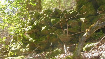
| A classically built rock wall that supported the old bridge abutments that no longer have a bridge to support! |
 |
| To see the bridge remains, walk downriver along the rocks from the abutment to this area where the river narrows. It's also a nice place to catch some sun and picnic. |
 |
| Where is the old metal bridge then? Look across the river into the vegetation! |
 |
| Watch your step when you get to the river because there are still cables like this one anchored into the rocks that can most inconveniently trip you! |
 |
| Upriver view from below the bridge abutment. |
 |
| The kids can have fun looking for lizards and salamanders! |
 |
Or other wild things! These prints were near our tents in the morning, but nothing was disturbed. Good advice to bear canister your foods though. |
Below is a topo map of the trail you can enlarge by clicking on it. Another fine place to camp, especially in colder weather, is on the ridge.
In winter or spring the ice remains on vegetation down in the canyon. It is a thick frost that looks more like snow at a distance! You may sleep warmer at the top, and your short hike to the river might be more enjoyable.
Driving Directions:
- Take Foresthill Road at Highway 80 onto
- Auburn Ravine Road.
- Turn right onto Mosquito Ridge Road.
- Follow it into Tahoe National Forest, continuing until you see the sign on the right for Mosquito Ridge Access Trail. There is a large dirt turn out for parking on the left and the trail heads uphill on the right.
For more possible hikes for you:
Trails by Areas:


No comments:
Post a Comment
Thank you for your visit to Peachy Hiker's place and for taking the time to share your thoughts!