 |
There are some amazingly rugged waterfalls and cascades along the creeks,with especially inviting pools on the way to Island Lake. |
 |
Fall colors are vivid contrasts to the granite along the Twin Lakes Trail.Taken in Sept. 2012 |
Miles: Our round trip was 7.95 miles with stops at ponds, lakes, creeks and waterfalls.
Elevation range: 7,000 - 8,120 feet (3,197 total per Basecamp, Garmin 62s)
Difficulty: Moderate~Strenuous. It is uphill, rocky, and around 8 miles. Some skill is needed to look for and keep on the trail. Avoid following cairns. They are often down on your return trip and unreliable. You never know who placed them or why, or if their destination was the same as yours. Same idea if you set them up. They could very well be gone on your return trip. Use the terrain, lakes and creeks as guides to stay found, and GPS, map, and a compass if you can.
Driving Directions: From Highway 50 near Kyburz, CA turn north onto Wrights Lake Road. Note that the sign I saw only said "Wrights Road". Follow the signs passing Lyons Creek Parking, and Bloodsucker Lake parking, on to Twin Lakes Trailhead parking.
To the Trailhead: From the north side of the parking lot you'll see a closed metal gate. Go around it and follow the pavement a short distance until you see a sign for the Twin Lakes Trail and Grouse-Hemlock Trail that points to your right. Follow that and there is a big sign at the trailhead where you need to fill out a day permit, no fees, for entering Desolation Wilderness. The hike is pretty strenuous up to the fork toward Twin Lakes and Island Lake. It is rocky and has carved boulder stairs off and on. It winds through the trees alongside a creek, in and out of the sun. Once you head north again toward the lakes you'll spend a lot of time on the granite in the sun.
Notes: Sunscreen and sunglasses are a must. I suggest packing along a parka or hoodie in case of weather changes. It tends to be more windy up top too. Take plenty of water and snacks. Hiking poles are a fantastic help! To backpack, you'll need to contact a ranger station or go online to Desolation Wilderness website and get a permit there. There are minimal fees. Other regulations or restrictions can be found on that link also. Fishing there is very popular; be sure to have your license with you.
WILDFLOWERS IN JUNE: I am no expert but try to name them for the curious.
 |
| Along with wildflowers come moths and butterflies like this beauty, a Field Crescent Butterfly, and this one was camera friendly! |
 |
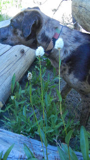
| Buckwheat |
 |
| Lily, the dog is playing in the water behind the Camas Lilies. |
 |
| Crimson Columbine |
 |
| Meadow Larkspur |
 |
| Pink Indian Paintbrush |
 |
| Monkey Flowers |
 | |||||
| Small Larkspur |
 |
| Along the way the views behind you are startlingly clear and distant. |
 |
| Lily found every pond and creek to play in! |
 |
| We were looking up along the way to the uppermost lake, Island Lake. |
 |
| We found the trail fairly easy to follow by looking for landmarks like these rock walls. |
 |
| There were stunted trees along the mostly granite hike on Twin Lakes Trail that offered us some shady respites from the glaring sun. Wear sunglasses. |
 |
| The trail over large areas of flat granite slabs were lined with large stones that made it clear enough to follow without doubt. |
 |
| This is one of several inviting brilliant pools along the way. They stood out vividly from the grey acres of granite. |
 |
| Not so inviting, but very helpful stones placed in the path so hikers didn't have to slug through the muddy area. |
 |
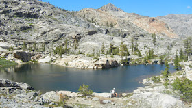
| Peachy Hiker (take by me) at Twin Lakes on the west side. My tripod was almost useless due to the winds up there, but the weather was perfect for this hike. |
 |
| Boomerang Lake |
 |
| This was the south side of Island Lake, still snowy in September! |
 |
| Another lake along the way. |
 |
| This map courtesy of Every Trail shows my GPS tracks and our speed. |
Every Trail:
Island Lake in Desolation Wilderness has elevation profile graph too! But ignore the stated speed. We were doing trail work along the way.
Island Lake in Desolation Wilderness at Wikiloc.
Related Posts
Desolation Wilderness
| |||
2015-07
|
10+ miles
|
Strenuous
| |
2014-08
|
30 miles
|
Moderate to Strenuous/Difficult
| |
2014-07
|
18 miles
|
Moderate-Difficult
| |
2014-06
|
12+ miles
|
Moderate to Strenuous
| |
2013-06
|
13+ miles
|
Moderate to Strenuous
| |
2012-09
|
Umpa Lake & Enchanted Pools
|
8+ miles
|
Cross country ~ Moderate
|
2012-08
|
Horsetail Falls via Pyramid Creek TH
|
Aprox. 10 miles to lakes at the top of the falls
|
"Difficult, and potentially dangerous" miles
|
2012-07
|
10 miles
|
Moderate
| |
2012-07
|
8 miles
|
Moderate-Strenuous
| |
2012-06
|
Lyons Lake via Lyons Creek Trail
|
10+ miles
|
Strenuous
|
2012-08
|
9.2 miles
|
Moderate
| |
2012-06
|
6+ miles
|
Strenuous
| |
2011-07
|
Lyons Creek Trail with melting snow
|
9+ miles
|
Moderate
|
2011-02
|
3.8 miles
|
Moderate
| |
2010-09 We hiked 12 days.
|
167 total
|
Moderate to Strenuous
| |
Updated links and facts, corrected spelling 06-2016
HAPPY TRAILS!
Updated Oct. 2013


No comments:
Post a Comment
Thank you for your visit to Peachy Hiker's place and for taking the time to share your thoughts!