Trails in Northern California

Trails in Northern California

Leave No Trace!

Visit desovw.org for more information about Desolation Wilderness. Visit Recreation.gov or call 1- 877-444-6777 to make park reservations. Visit Campfire Permits to get a permit online. More about Leave No Trace principles.

December 12, 2012

Donner's Castle Pass via PCT Snowshoeing

 
Difficulty: Strenuous.  Difficult to follow trail.  Undermelt hazards.  Numerous creek crossings of varying difficulty.  Could be more fun as an overnighter.  Fires are allowed during winter.
Length:  Ours was a 9.3 mile loop.
Directions and details:  Take I-80 to the Boreal exit west of Donner and east of Kingvale.  South of the exit make a left.  Stop at the hotel for a parking permit.  Your regular state park pass does not apply. The hotel has some vending machines with snacks. It is snowplowed in the event of snowy weather and has a nice restroom with vault toilets.  The kids can build snowmen and tabogan there.  Great places for snowball fights, too!  During the regular hiking season, there is an interpretive loop trail.

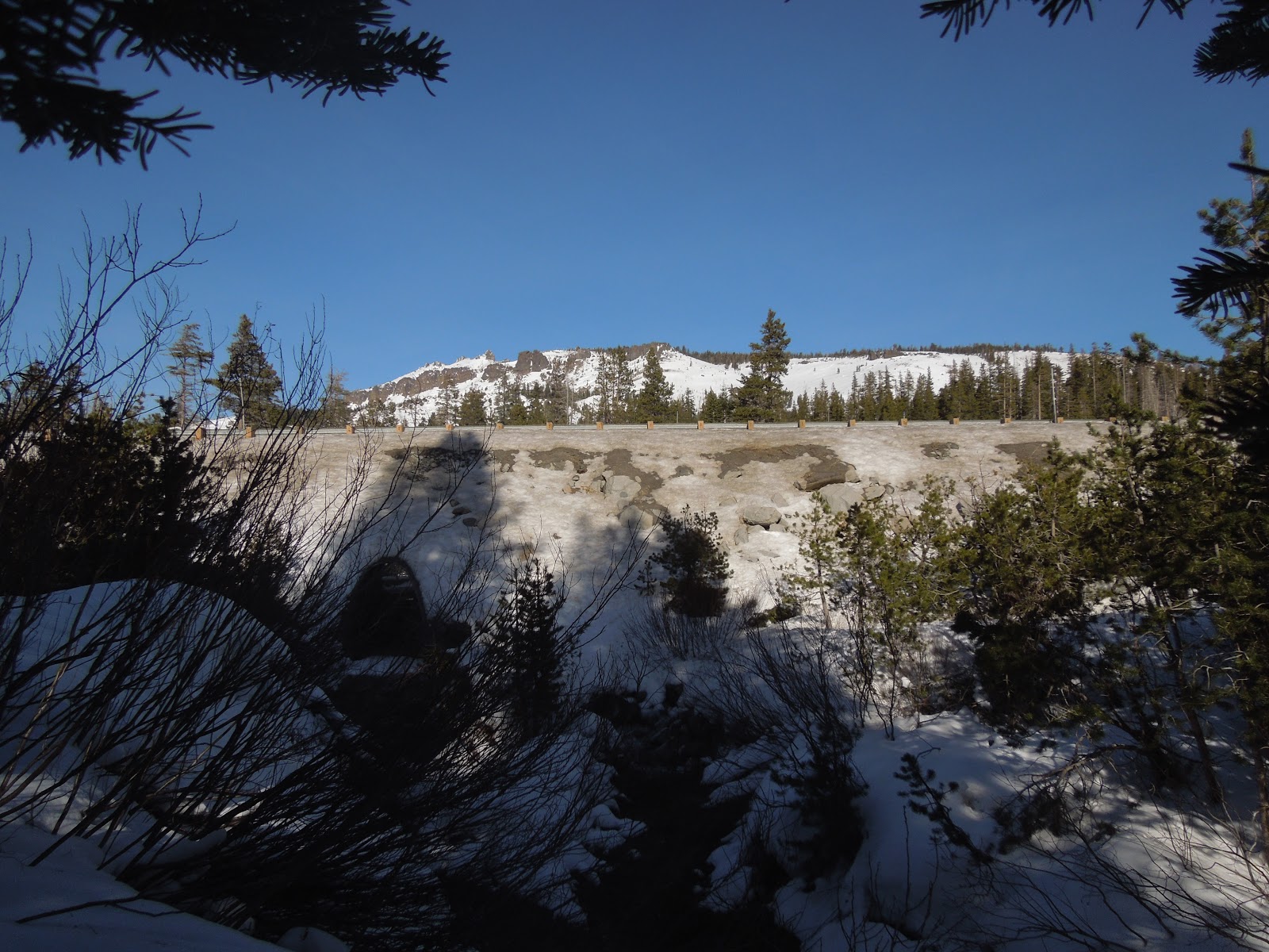
Taken by Peachy from Castle Pass looking south.
This was my second time out snowshoeing in my new MSRs made for virtually every condition.   You may remember that we each broke one of our trekking poles on our last trip so I had one of each set this time.  I ordered the new ones but they hadn't arrived so "Make do" as grandma used to say.  This time the sun was on our side rather than stormy weather, and I had mapped out a plan for a longer trail.  It seemed like a reasonable day's hike at 1 mile an hour average, expecting about 7+ miles and time for a meal. We used the sno park paid parking last week so we knew the ropes and were able to waste less time and get out on the trail.  (Pay at the hotel as you enter the parking area.  There are vending machines there, too.) Near the trailhead that is down the road in the loop is a vault toilet. Use the trailhead at the billboard sign turning north instead of south at the junction.  I was excited because our last trip was so much fun despite bad bad weather; this day promised to be stellar!
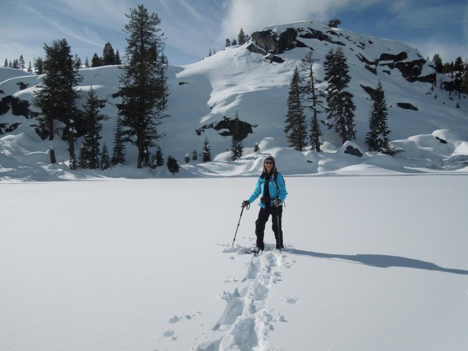
Our first creek crossing was wide and frozen.  We detoured a bit for a safer route. 
(Funny note!  Those are my mismatched poles!)  Those marks in the tree are trail markers.
The snow was sparkling, the weather was crisp but not bone chilling.  The snow was icy but I thought with sun it would soften up through the day.  (Guess again).

This widow maker is about to fall and is right on the trailside.

These photos are for fun and to show you to see what the trail was like:


Unlike the perfect dry powder we had last time, more effort was required to walk on this crunchy  snow and I found myself tempted to take the snowshoes off and just hike in my snow boots.  There were bootprints to follow and not much sinking, and I've done it before!  From the trailhead we made our way easily to the tunnel snown above that goes north under I-80 for the PCT.

You can see the trail to the left.


Once we crossed the highway it took some effort to stay on the trail because no one had been on it this far back  The sports store said lots of people were here yesterday so we expected broken trail all the way. 


There are few markers along the way and the GPS was a frequent help.
We wound through the woods and conquered one undocumented creek crossing after another.
I like those, but in the deep, crusty, unbroken snow there may or may not be a faint look of a trail buried. At the creeks we faced steep banks of one to three feet, the water (sometimes a foot deep) and the other bank would be as much or more of a drop off. 

The water running under the snow made the possibility of the bank breaking
into the creek, taking the hikers with it, an unpleasant thought. 
Here we went downstream to cross.

Troopers that we are, we kept going and with umpteen detours
for "safer" passage, we would leave and refind the trail. 

One of the few PCT markers, and imagine, no bicycles!
After several miles of detouring, it seemed like the GPS predicted the same distance to our destination which was confusing because it continued showing our tracks as progressing right along. 


In so much shade we had to stop and get me some layers, but we were dry and still happily challenged.  No conversation was possible unless we stopped because the crunching of the snow under our snowshoes was so loud we couldn't hear each other!  No kidding!

Finally we reached an intersection of trail junctions and had to choose that all go northerly, just more east to more west.  None was the obviously correct route and GPS wasn't a help at this time. Upward to the most northeastern direction was our choice. My quads, calves and even the tops of my feet were so achy, my usual penchant for going uphill had vanished.  I just wanted to stop and heat water and eat. 

We were finally heading up out of the woods and getting some distant views.

Peachy Hiker taking a rest!

At the top we were on a wide open ridge with breathtaking views all the way around!  We were buffeted by extreme winds that actually took me and another hiker completely off of our feet, in snowshoes, and threw us to the ground - me twice!  First time in my life!

The ski runs to the southeast.


Castle Pass to Castle Peak, and by our shadows you can see the sun is falling in the west.
The GPS showed us on another ridge to the north!  It wouldn't move either so clearly it had lost function.  Now getting later in the day, and being tired, we knew we faced a headlamp snowshoe back to the parking in possibly more unbroken and invisible trail. 


Achy and sore, but invigorated by the fantastic views, we headed downhill to the west southwest.  It was like a freeway.  Snowshoers, a snowmobile, cross country skiers, and hikers had made it so much easier by packing the snow and making the trail clear, plus it was all downhill.  How often do you hear me being glad about going downhill, but I was rapturous! 


Our whole hike totaled 9+ miles (we expected 7) and we did end up using headlamps, but only at the end and not a concern. 

Advisory:
The PCT wound through the woods and if you are experienced at finding your way in snow without anything but a map and compass, this route was untouched and had everything the backcountry offers. 


We had fun crossing creeks and identifying animal prints in the snow. If it were powder I would have been more thrilled!  At the end of the day I had sore muscles and an enormous sense of accomplishment.  Honestly I am not as sore from this hike as the last snow trek.  Our photos are prettier without the stormy grey images we got last time, too.  The views made it tempting to stay on Castle Pass for sunset and if I were familiar with the trail back, I would have.  The GPS failed twice on the trip so I posted our tracks but suggest searching for additional tracks to Castle Pass, PCT, and Peter Grubb Hut. Our map is shown below.  I drew in the places the GPS didn't record.  A handful of people have GPS tracks posted of hikes in this area, but be aware that in the snow, the trail is virtually undetectable in many places.


HAPPY TRAILS and as usual, remember to take plenty of water, snacks and food, layers for warmth and a first aid / safety kit.  I always say take a light source and way to start a fire.

Trails by Locations
Peachyhiker's GPS Tracks
Articles by Titles


If you appreciate our state parks (and sno parks), consider this letter I received and join in!  With membership you get a parking pass and other amenities, plus help keep our parks all open.
Dear Reader,Double Your Donation
Throughout 2012, our parks faced budget cuts, development threats and more. And next year's budget battle will be challenging.
The good news is you can double your impact with your tax-deductible gift today, which will be matched dollar-for-dollar!
That means your contribution of $75 or even $150 to California State Parks Foundation will go twice as far. But time is quickly running out – as this match only lasts until midnight on December 31st!
Your support has never been more important! We nearly lost 70 of our state parks this year. But it would have been a lot worse without supporters like you.
Stand with us and stand for parks today by making your tax-deductible, year-end contribution to the California State Parks Foundation.
Don’t lose any time! There are just a few weeks left for your support to do twice as much for our state parks! So please, double your gift – and your impact – before the clock runs out at midnight on December 31st.
Thank you again for your continued support this year and in the year to come.

Sincerely,
Elizabeth Goldstein
CSPF President and fellow supporter
Updated 12-14-12

December 02, 2012

Donner PCT TH to Flora Lake ~ Snowshoeing in 2012 with 2016 photo update

See Donner from the Flora Lake hike. Visit snow covered, iced over ponds and lakes. This is a memorable snowshoe experience!

The Sno Park is a great family fun place! Toboggan, build snowmen, make snow angels, and have a snowball toss (with close parking and restrooms)! 

Peachy Hiker on the lake, very well iced over in  September 2015.
 Azalea Lake, a frozen beauty queen!

And it is right off I-80 at the Boreal exit!

Snowing so hard over I-80 we couldn't even see tail lights in 2012.

Quite a few of my photos are not showing any longer.  Not sure why so I am editing those out today (Aug 28, 2015).  I will go for replacements this winter assuming we get snow!  For now and ease in updating, I am leaving the captions.  Sorry for the difficulty!  This link still has all of the photos:  GPS tracks 

Along your way are creeks to cross, views to take in,
and photographs waiting to be taken.  Great backpacking destination!
  • Distance:  Posted is out and back totaling about 3.5 miles
  • Difficulty:  Easy+ at this time.  Nothing steep.  Conditions can change quickly so check forestry sources if you are concerned. 

Now let's get you going!

Advisories:

  • Carry food, and plenty of layers. Be prepared for all weather. We encountered rain, snow and sleet. It got windy and colder late in the afternoon.
*** Find GPS links and a map at the end of this article!

(Missing image)   In the snow, Everything had a mystical aura.


The Sno Park is likely to be full of families playing in the snow and building snowmen.
This creek offers a bridge, but there may be creek crossings ahead!
Gaiters helped me stay dry.

 It appears that there is a seasonal Interpretive Loop.


(Missing image)   The first large icy pond beside the trail.

 Looking back at our snowshoeing path!
 The photos, despite all looking quite grey, are really in color!
 Haha...We headed toward PCT and Donner.  Sometimes I got ahead of myself and
landed on my knees by clipping the back of one snowshoe with the other. 
Take your time...

(Missing image) 
If you stay on the PCT you will see markers on trees. This route breaks off of 
the PCT to get to the lakes, so this is the only one you should see on this trek.

Good insulation kept me warm, but I did
have to change layers on our way back. 
I carried my usual safety supplies and first aid kit
but was so engrossed in the trip and
achieving our goals, I forgot I had a rain poncho
It could have been used over my daypack in the heavy moisture!
We were snowshoeing in a storm.

(Missing image) Flora Lake, inviting and picturesque.

(Missing image) We could see Donner Lake from here but it feels like a "Where's Waldo?" view!
(It is near the center in the "v" between the dark hill and the snowy one.)


We each had our poles broken on this trip...wow.  My new set is ordered, but what a
strange problem.  From reading, the aluminum poles are stronger (slightly heavier) but
what good is it to carry out the weight of broken carbon poles and do without any benefit?  My
new set has my coveted cork material handgrips, soft wrist straps and a locking mechanism.

(Missing image)  The storm wasn't taking breaks at high elevation.

 This creek usually has water, but creeklets were pouring under the snow.  It took some
searching to find places to cross.  Use caution.

(Missing image)  Donner Lake is in the "V" behind the tallest sparse tree.

 Approaching one of the unnamed lakes and ponds that are all iced over.
Iced over pond.  I wouldn't recommend
 stepping on any of it.

(Missing image)  Bridge to civilization and a weather break.
 Almost back to the car!  Photographed from the bridge.  The blur is snow.
I highly recommend this trail for snowshoeing!!!

The trail in red is what I posted for GPS tracks from this snowshoeing trip. Our side trips
are edited out. GPS tracks supplied are accurate regarding areas where we had to detour
due to trail conditions, and may diverge from what a forestry map shows, or maybe from
conditions when you arrive.
The pink trail is one I hike from the Old Donner highway (the brown line) during dry seasons, but is included for your frame of reference. (Posted on Wikiloc)  I would still like to snowshoe
all of that from Old Donner Highway to I-80.
On January 5th, my daughter in law, Kristin, and I went up and below is our map of tracks.  We followed snowshoers tracks mostly, but blazed our own tracks east and just beyond Flora Lake to our Donner view lunch spot, perfect for a great view on a sunny day!

Reviews of other trails in Northern California: Trails By Locations
Or: By Titles
    Thank you for dropping by!  Happy Trails!
If you like this article, please share it by clicking on the buttons for social media below for your convenience! 
Thanks again!

updated 12-14-2012
updated 8-28-2015
updated by adding the standing on lake photo and rearranging the Advisories text 1-4-2016