Trails in Northern California

Trails in Northern California

Leave No Trace!

Visit desovw.org for more information about Desolation Wilderness. Visit Recreation.gov or call 1- 877-444-6777 to make park reservations. Visit Campfire Permits to get a permit online. More about Leave No Trace principles.

November 28, 2012

Miners Ravine Reserve in Rocklin, CA

Miners Ravine Reserve in Rocklin, CA offers two short historical loops. 

     One trail is interpretive and is .5 miles long; both have benches along the way to pause for moments of reflection.  An overgrown brooklet runs through the area shaded by oaks, but where blackberry briars impede hikers from wandering off the designated trails.  The poison oak appears to have been removed, although I would watch for it.  This is also a natural habitat for rattlesnakes.  There is an information board in the parking area that gives the historical significance of the area previously known as Allentown. A map of the trail is shown.


 The trail heading south of the parking is posted.  It is wide and well maintained.


 A real oak leaf, not poison oak.  (I didn't see any poison oak,
but it loves this area, so do watch for it.)
 
 Signs like this are part of the interpretive loop.

 From the north side of the parking lot is a short loop that is well shaded and 
offers recognition in the form of a plaque and a bench.
 
 I was surprised to see this bloom so late and with so much "weather" lately. 
They are quite beautiful and colorful!

 This section is typical of what to expect.  The benches may be damp or wet this time of year (autumn) but are serene places to sit and enjoy the fresh air and wild outdoor setting.


 This is the memorial bench.


There are some blooms and lots of autumn color amidst the thick blanket of berry briars.  Along the creek cattails are tall but few.  You can take your dogs for walks on these trails.

     Large parking is available which is located on the west side of Auburn Folsom Road, north of Douglas Blvd. in Rocklin, CA.

Happy Trails!
 

November 27, 2012

Poison Oak ~ Information, Treatment, and Photos

This page is dedicated to my family, friends, and readers who may be allergic to poison oak and need help identifying it in all of its various stages and forms. Included after the photographs are pointers to help prevent adverse reactions.


Here in northern California there is poison oak 

flourishing along otherwise great hiking trails. 

You're unlikely to find poison oak over 4,000 feet elevation,

but keep in mind a trail's elevation changes.


Taken on the One Eye Creek Trail near Georgetown, CA.

To get to an amazing 100 foot wide curtain waterfall at the other end of this trail, it's wise to dress for poison oak.  Here the poison oak "ground cover" is surrounded by forest, but has an open area of sun.  All of the low growing green plants in the photo are poison oak!  And the trail winds through it.  For hikes like this one, long pants, boots, maybe long sleeves, hat, and gloves would be appropriate. I take a small tarp to sit on.  
 

 NOT poison oak!
NOT poison oak!
True oaks grow leaves singly rather than in groups like poison oak.

I took this photo of poison oak along Cardiac Hill Trail in Auburn, CA this March 2013! 
 It is everywhere, tall, bushy, vines, hidden, and looming like grand shade providers!
http://peachyhiker.wordpress.com/2013/03/12/cardiac-hill/ for more photos.


Taken on the trail to Fairy Falls, also known by other names, in the Spenceville Preserve near Camp Far West.  That IS poison oak.


This shows you poison oak in bloom. 
And pay particular attention to the three leaf structure.  The top leaf extends more than the others which grow like arms out to the sides.
 

Here is what is left of this dormant poison oak plant.

SERIOUSLY! Look how invasive the poison oak can be!  It is under the bark of this tree.
 

Taken at the Harvego Bear River Preserve by Steve Vilter.  Used with permission.
It often is a low growing shrub as shown above, but it can create vines that hang on to trees, although in California, that is still poison oak, not poison ivy. They may also be red or reddish in spring.  They can use aerial roots to cling to trees, neighboring plants, and mossy rocks to climb for sunnier spaces.  The woody stems contain the oil many are allergic to.  Avoid touching any part of this plant including the roots, leaves either alive or dead, flowers or berries.


On the Olmstead Loop in Cool, CA.

Above is another form these plants can take.  The tall branches in the foreground of the pine tree (8-10 feet tall) are poison oak that is dormant for the winter.  Touching it can cause the dreaded rash.  


A close up of the same tall poison oak above
when it was dormant.  It may have an orange or reddish tinge, maybe burgundy,
from the oils, but smoother texture than other bark or branches nearby.


Notice the difference in the large tree trunk and the "branch" growing up in front of it.  The texture is smooth, unbarklike, and sort of rubbery or polished lookingIt is poison oak.  If you look at the base of this oak tree below, you will see a number of shoots heading up from the ground that have that smoother texture and are a different color. When wood is dark, it is the oils that can wreak havok for the allergic. Avoid contact.

The small darker stem growing up the tree is poison oak sending up shoots to climb the tree.

This is a typical poison oak habitat.  It likes shrubs and trees to climb and imitate; one might believe just to fool the allergic!  It takes various forms even in this small setting, from vine, to climbing tall branches that look like part of a tree, or small bushes.  It can be a foot tall shrub or a 10 foot tall one.  The unique leaves and stem characteristics become clear the more you look for it.
 
In late spring and summer the foliage is glossy and may be turning colors as shown below.  The leaves are not necessarily smooth but may be fuzzy.
 
Taken along the river south of the Magnolia Equestrian Staging Area along CA 49.

In the fall and late summer, maybe early fall, poison oak leaflets are quite pretty,

displaying an array of autumn colors and are photogenic too! 

As the seasons change
and the leaves fall, be aware that they still contain the oil
that causes the miserable, oozing, itchy, red rash, so watch what you have contact with.

This plant's leaves have the lobed edges, glossy spring growth
and reddish coloring typical of poison oak. 
 In areas where it is growing like ground cover it doesn't look like a threat,
it just looks lush, healthy and pretty. 

 Prevention:

  • Avoid any contact with any part of the plant and avoid touching pets and equipment that has had contact with the plant.  Dead plant parts may still have oils that cause the rash.
  • NEVER BURN poison oak that is dead or alive. (Be careful about firewood you pick up.)
  • Take plastic bags for boots and maybe even a change of clothes for the drive home.  
  • Medical sources say use rubbing alcohol as a rinse, followed by rinsing with cold water is most effective in preventing an outbreak. Avoid rubbing too much. Mainly try to rinse as much as you can. Water dilutes the oil but cannot dissolve it.
  • It is not best to use hand wipes. They spread the oil on your skin and rub it into your pores. Soap can't dissolve the oil either, but you can use it if you rinse well and avoid rubbing it in.
  • If you can, prepare ahead by having a gallon jug of water and rubbing alcohol for cleaning up. I do carry it in my car to clean equipment anyway.
  • If your dog is along, and it touches the oils, your contact with the pet can transfer the oils to your skin and it is best to wash thoroughly within 5 minutes
  • Also, using rubber gloves, remove your clothes and launder immediately. The warm water will remove the oil from your clothes.
  • When you are finished handling your clothing, clean oil from the gloves with rubbing alcohol.
  • If you develop a rash from poison oak contact, it can be within hours or may take weeks from the time of contact.  It is not contagious, even if you develop the oozing blisters.  The fluid is your body's attempt to push the oils out of your system, but it does not spread the rash.  If the rash spreads it is simply part of the process your body uses to remove the oils. 
  • Recovery may be fairly quick (average is around 10 days) or may take as long as 4-6 weeks for severe cases.  Over the counter products may help according to my friends who battle this allergy, but most end up getting medication from their doctor. 
If the rash gets around your eyes or genitals, or if you can't sleep due to discomfort, check in with a doctor. If you have difficulty breathing of course, call 911. 

*  I do not get rashes from poison oak contact.  My information is from reading medical reports, websites, and from friends who hike and are allergic to it.  If in question, talk to your doctor for preventative recommendations and treatment.  My hope is to offer photos and descriptions that help you identify the plant and prevent contact with it.

Happy Trails!
 I have learned about poison oak from many sources, but here are some sites you can visit for information:
 
 
Updated 12-2012


November 14, 2012

Sierra Big Trees and Grouse Falls Overlook

Short hikes suitable for families with rewarding views,

in El Dorado National Forest and Tahoe National Forests!

Sierra Big Trees has an Interpretive Loop (not boring as it sounds!) and fantastic picnic areas. 

 
There are restrooms at the Big Trees Trailhead, and looming above are magnificent giants!
 
 
The path is well maintained, lush green, cool and inviting.  It's short enough to be fun for even littler kids. 
 
 
Those are my hiking poles propped against this tree to offer a size comparison to this ancient fallen tree. 
 
 
I wished my camera could show you the whole tree.  This grove is protected from logging, and thankfully, so that we can see firsthand what a camera cannot do justice to.
 
 
Grand blooms lined the trail as well, lending to the sacred Garden of Eden atmosphere.


For the avid hikers, there is a longer route, and for others, a shorter and easier route.
 
 
Snow flowers stood tall and in full color near the end of the loop I took. 
I didn't take GPS as both trails are easy to follow.  Elevation change is negligible.
 
 
There are ample picnic areas equipped with grills and picnic tables.  They are well spaced too, ensuring that feeling of getting away from it all.
 

Sierra Big Trees Driving Map


Grouse Falls Overlook

in Tahoe National Forest

The down side is that to get to Grouse Falls Trailhead, you drive about 5 miles of winding dirt road. 

 
Once there, parking is ample, but the only restroom is the woods.  The trail is well maintained, wide and mostly shady.  Current Conditions link.


After a good stretch, it would be fun to grab lunch and drinks to share out on the viewing deck.  The exception is hot afternoons because the deck isn't shaded and gets the western exposure.


I take things like this pine cone for granted, having grown up in the woods, but really!  The size is a marvel of nature!  My feet aren't so small and the pine cone is close to two of my foot lengths.


There is a dilemma on this short hike.  The shade is dreamy on a hot afternoon.  There is a water runoff I could hear but not see through all the plants growing in the gully.  It cooled the air, pleasantly gurgling. It also unfortunately made me, the hiker, fair game to skeeters, the ravenous ones.  Now for some freaky reason, they rarely bite me, but they still buzz around my face, into my eyes, nose and mouth, and generally disturb my zen-ness in the woods.  Take your remedies for this.  I wished I had a fly swatter!


And when you arrive at the garden like feature of decking, the view across the canyon is the Grouse Falls which cascade 504 feet in two drops called "tiered horsetails".  My point and shoot wasn't prepared for this shot.
There are two other nearby falls you can visit:  South Branch Grouse Creek Falls and Peavine Creek Falls.  I went on to visit the Sierra Big Trees and up to French Meadows instead.
 

Driving Directions:

From I-80, take the Foresthill exit on to Foresthill Road and drive 16.7 miles and turn right onto Mosquito Ridge Road. Follow Mosquito Ridge Road 19.25 miles to a left turn onto Peavine Road (Road 33). Drive to the end of this winding graveled road to the Grouse Falls Turnoff. At the end of this short spur is a parking area where the trail begins. 
The map above shows from Highway 50, but if you enlarge it by clicking on it you will see how to come from 80 or 50. 
HAPPY TRAILS!!!


November 13, 2012

Canyon Creek Falls near Georgetown, CA

Hike along forest roads, going gently downhill to find this 83 foot waterfall!  The kids can do this if they can walk 5 miles round trip. 


     I read about this waterfall on a blog last year but when I searched for more information, even the World Waterfall Data Base didn't show it. My book of California waterfalls didn't list it either.  I have tried before and this hike was another attempt. I headed out without specific information other than where to begin the hike, the name of the creek, and that you follow old logging and forestry roads; no other helpful directions. 


     My victorious hike surprised me a little with snow left on the ground from fairly recent stormy weather, but I had my jacket and gloves, gaiters, waterproof boots, and enthusiasm.  Plus gas is expensive and I wasn't about to turn back now!

    
     Holy Surprises!  I found three mounds of fresh bear scat in a short distance so I talked loudly to the bears while hiking down the muddy and snowy road. The sounds of snapping branches behind my camera-bug pauses kept me alert.


     My day was chilly enough to wear my jacket and gloves, but the sky was blue with floating clouds and the tree tops didn't even hint at the snow carpeting the forest floor!

    
     Down the road, as my elevation declined, the snowy floor dried and the trees thinned.

    
     I heard the rushing sounds and at last I made it to Canyon Creek, giddy with hope that I had time to scout out the creek from here and find the falls.  I had no idea how far or which direction they may be so I headed east, upstream.  It's a beautiful season, but the leaves were thickly blanketing the "trail" and being so wet, were a bit slippery.  The creek was a symphony for me, and I hoped it was a waterfall creating the commotion.

SUCCESS! As you can see from the photo, serendipity and intuition led me there!


     I saw the top first, and with water levels being what they are right now, crossing back and forth trying to find a perfect place to photograph the falls was nothing like the challenge I had expected!  My foot sank a little deep and the boot can only do so much to keep me dry!  There is an active mining claim here and the trail was decent, although buried in wet leaves.


     This is looking back downstream from the waterfall.  There is snow still in this heavily shaded area, and the temperature reflected it.


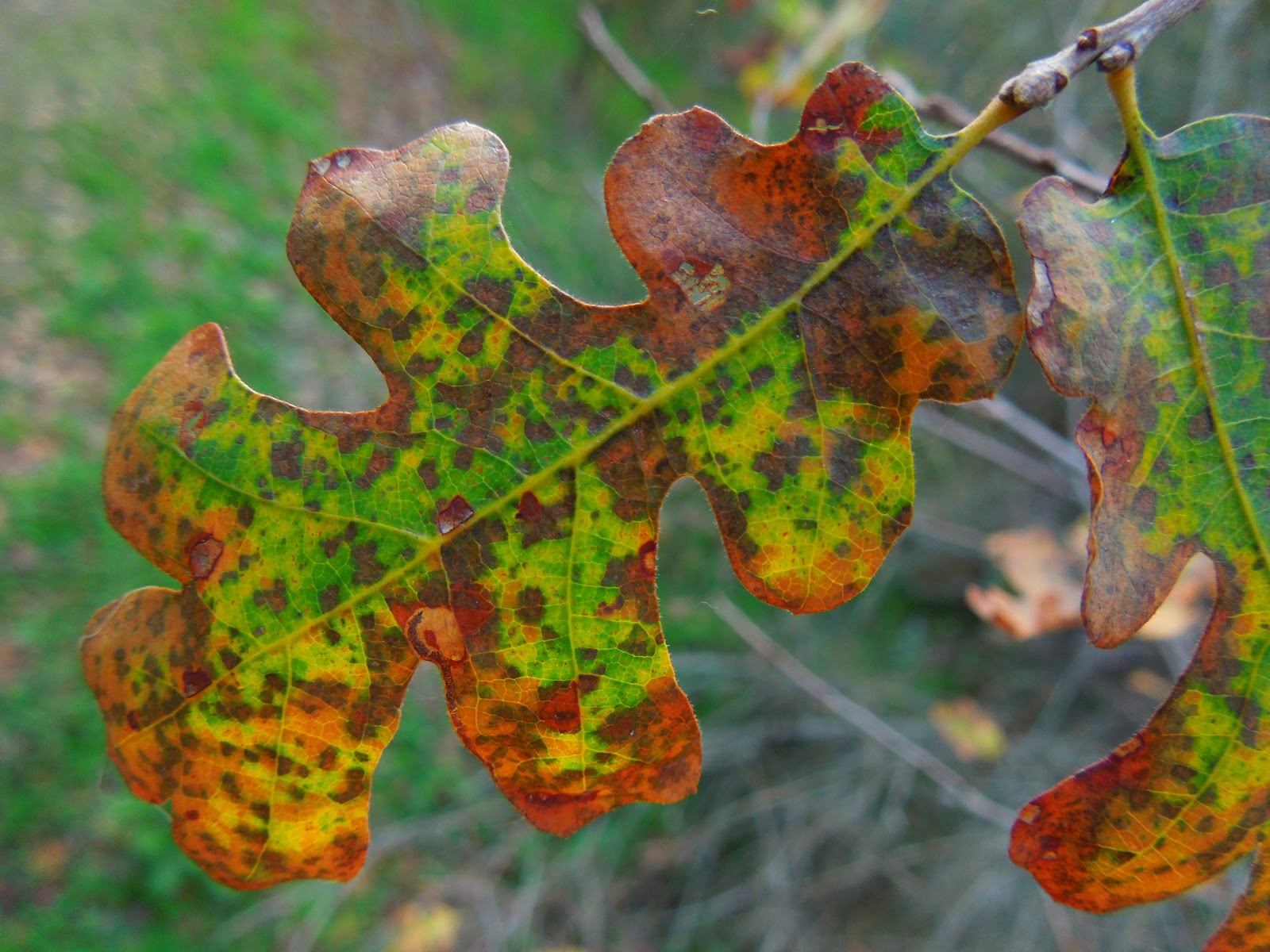
 The woods are colorful now rather than all green.


     I stopped here for photos and heard breaking branches in the gully behind me so I gave the bears a yell, looked around, took another snapshot, and returned to the car.  I was elated to have found this prize waterfall hike and am happy to share it with you!


Forks in the road are marked with waypoints and arrows or notes.

Directions: 

Clock your mileage from the intersection in Georgetown where you turn onto Wentworth Springs Road (like any old town "Main Street") and go 10.5 miles.  Turn right at the sign for the Bald Mountain Staging Area, but pull in on the right at the first dirt road and find an out of the way place to park.  You will hike down that road.  It is gated and crosses private lumber property for a mile or so.  There are not "No Trespassing" signs, and it is marked with a small company sign. 

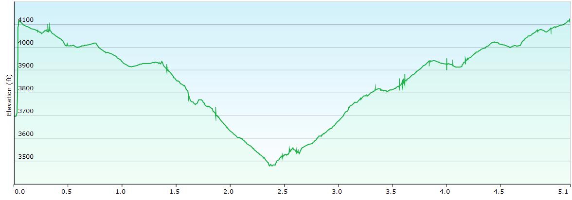
I hiked further but the trail above is 4.9 miles out and back, after I took out my other detours. 


Difficulty: Moderate due to elevation and to the creek side trail being almost a bushwhacking. Plus you cross the creek at least once to see the falls, really twice for a nice view.


This is a summary of my hike.  I certainly took my time, stopped to eat and photograph.
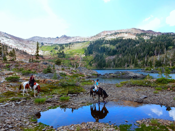
This area has OHV areas closed for the winter, but available post snowy season.  There is ample parking for horse trailers too and equestrain traffic is welcome.


I caution you to use your discretion about hiking in across private property.  And above all, please be responsible. 

There are no restrictions about hiking on a mining claim, but don't pan for gold! 

For more trails, click here 

Thanks for stopping by and HAPPY TRAILS!