 | |||
| One of several cascades we enjoyed finding, Tarzan vines and all! |
Difficulty: Easy to strenuous depending on your choices. Getting to some waterfalls is narrow and steep.
Elevation range of this hike: 891-1822 feet.
 |
As you can tell from the photo, we had the good luck of nice weather. The trail has lots of shade and along with the creek, waterfalls and pools, it was a nearly perfect day!
The trail starts out wide and heads downhill, but soon enough it will narrow and occasionally the footing is less secure. My hiking poles help me balance in the steep areas. Good shoes help too. At the first fork, go right, down toward the stream.
 |
 | |
 |
| Wildflowers were blooming profusely in open sunny areas. |
There are several creek crossings even for a short version of the hike but they are equipped with stones you can usually step across.
We sat at the top of this waterfall, in the shade, cooling off from our hike through dense, tall, rather pretty poison oak to get to this spot along the stream. It involved a little boulder scramble and creek crossing too. We made it with dry feet and hardly any biting bugs!
 |
For the adventurous, there is even a Tarzan vine hanging over the falls
and pool! I am not saying try it out, but tempting, huh?
|
 |
| Downstream view of a pool from our snack/rest rock at the top of the falls. |
Our next challenge was to get from our resting boulder up this stream to another waterfall and pool without wearing waders! Some of the rocks are slippery, but we made it, more wet from sweat than the creek.
We arrived at this tranquil, inviting waterfall pool, and even more fun was the knowledge that we had a secluded wilderness experience right downhill from a neighborhood of hikers, bicyclists, and equestrians, but got the trails and pools to ourselves.
***The following photos are from Sept. 20, 2012. Water was so low that I couldn't get a decent shot of American Falls, so settled for a few of the hike and the creek:
 |
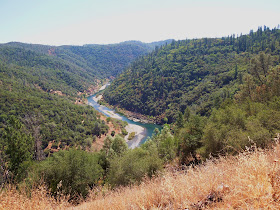
| My first view of the canyon on this day's hike. |
 |
| Looking for places to experiment with my new camera, I headed down the canyon farther and at this creek crossing found this fella. You can see how little water was flowing. |
Just another pretty bend in the creek with colorful foliage.
Driving directions: Take Highway 193 east from Cool, California for 5.8 miles. Turn left on Sweetwater. This is known as the third gate of the gated community.
If you see the sign for the town of Greenwood, turn around. On the day we went here the street sign was missing, so all I can suggest is drive slowly, watch your mileage, and make sure you don't pass the sign for Greenwood.
When you have turned, you will see the small free parking (in spring of 2012) at the trailhead on your right before the gated entry into Auburn Lake Trails Community.
ASRA ~ Auburn State Recreation District
- BLM ~ Bureau of Land ManagementNear Auburn, CA
State Park In Coloma: - Dutch Creek Falls
Peachy Hiker's Table of Contents
Updated 7-2013
Edited May 2014


hello laura, thank you for being a great person, i am so happy that we met. i look forward to spending time with you in the back country. i love the photoes, merry chrismas sincerely art
ReplyDeleteThanks Laura for posting all these great hikes. I live on the divide & had never heard of some of these great local hikes until now. THANKS SO MUCH. Appreciate it!!! ;-))
ReplyDeleteAmazing natural scenery sir. I like that
ReplyDeleteI appreciate comments, especially ones that are from people who are finding new hikes in areas they hiked in but had not known about, and in cases where people have gotten on the trails because of specific information I try to provide so one feels more secure going to new places. Happy Trails!
ReplyDelete